


DELMARVA - Late Monday evening, a cold front slips through coastal Sussex County and Ocean City, Maryland, bringing a final round of light rain before drier air settles in. The last of the showers should taper off near beach towns like Lewes, Bethany, and Rehoboth by about 6 p.m., with clearing skies pushing in from the northwest as the night wears on. Skies won’t be crystal clear overnight, though, thanks to a strong upper-level jet stream—a fast-moving ribbon of air at high altitudes—that drags some high clouds overhead. Despite the clouds, temperatures dip into the upper 30s and low 40s near the shore, typical of post-frontal cooling due to descending drier air behind the front.
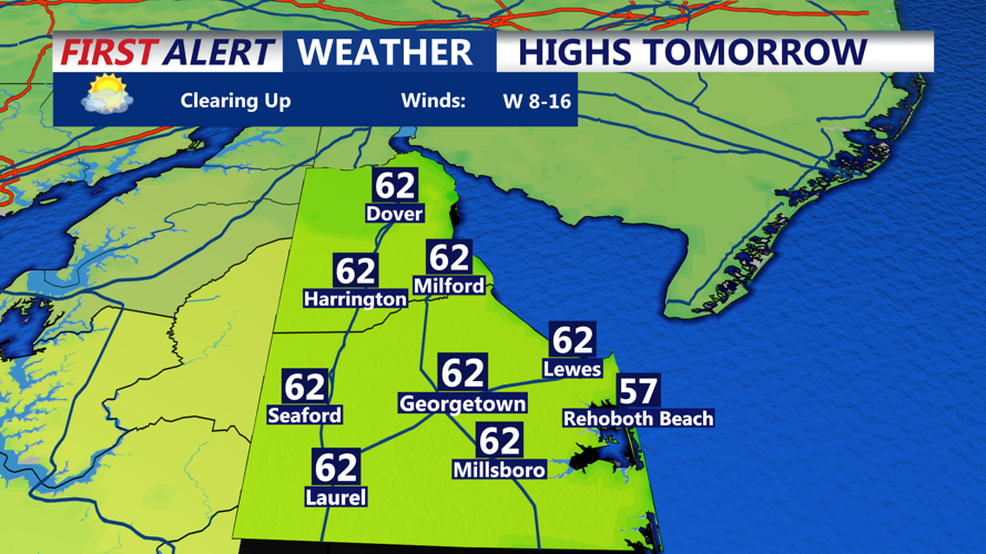
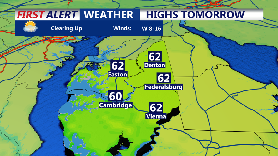
By Tuesday, high pressure gliding across the southern Mid-Atlantic brings a temporary reprieve. Skies are partly sunny early, and with a steady southwest breeze—driven by the pressure gradient between the departing low and incoming high—temperatures climb into the upper 50s to low 60s along the beaches. Gusts could occasionally reach 25 mph by late morning, giving the day a breezy feel. Clouds begin to increase again by late afternoon, but any rain holds off until after dark.
As night falls Tuesday, a fast-moving “clipper” system—so named for its speedy, low-moisture origins from Canada—skirts just south of the region. While most beach areas in Sussex and Worcester counties won’t see heavy precipitation, a narrow band of showers may brush the coastal plain after midnight, especially closer to Fenwick Island and Ocean City. With lows in the low to mid-40s along the shore, there’s no threat of wintry mix here—just light rain, if anything at all.
By Wednesday morning, the system exits quickly. While clouds may linger early, skies should gradually brighten with a drying trend and modest northwest wind. Highs will remain seasonable, hovering in the low to mid-50s along the coast. The air aloft remains slightly unstable due to lingering upper-level energy, but beach towns will likely escape the stray inland showers expected further north.
Wednesday night turns colder under mostly clear skies and a steady breeze out of the northwest. Lows drop into the mid to upper 30s along the beaches, a chillier-than-normal night but not uncommon for early spring transitions. A reinforcing shot of high pressure keeps Thursday dry with highs again in the 50s near the ocean, though some high clouds may return later in the day as warm air begins to creep in aloft.
By Friday, a warm front lifts north, allowing milder air to filter back into the region. Beach towns from Dewey to Ocean City could see temperatures pushing the mid-60s, with morning lows staying above 40. While most of the rain with this frontal system stays north, clouds will be noticeable and the atmosphere may feel a bit muggy compared to earlier in the week.
The weekend brings the most noticeable warm-up, as a southerly flow strengthens. With the front stalling north and high pressure holding just offshore, warm air surges up the coast. Expect highs well into the 60s—and possibly the low 70s—across the Delmarva beaches. This warming is due in part to strong warm-air advection: the process of warm air being transported horizontally by the wind, which helps moderate temperatures along the coast despite chilly waters offshore.
Rain chances stay low Saturday and during the day Sunday, especially across the southern half of the region. But by Sunday night into Monday, another frontal system approaches from the west. It could bring showers across all coastal zones late Sunday into Monday morning, followed by a final mild push before the next cooldown. With strong pre-frontal southerly winds in place, Monday may start in the 50s and push into the upper 60s or 70s once again before the front sweeps through.
The week’s pattern—defined by alternating highs and lows—is classic for this time of year. The tug-of-war between lingering winter systems and strengthening springtime sunshine sets the stage for rapidly shifting conditions. Thanks to dynamics aloft like the jet stream steering surface systems, each day feels like its own chapter in a story that’s slowly turning toward spring.