


DELMARVA - A weak backdoor cold front will continue to move southwest through the region into early evening, bringing more clouds, a brief period of breezy conditions and a slight chance of isolated light showers.
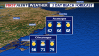
Most of Sussex County is expected to stay dry, though a few showers could develop mainly across eastern areas late this afternoon or early this evening. Rain chances remain low, near 20%.
East winds will run around 10 to 15 mph, with gusts near 20 to 25 mph at times before quickly easing this evening.
Late tonight will feel chilly for early June, with lows falling into the mid-40s to low 50s. Tuesday is expected to be dry and seasonable, with comfortable afternoon temperatures and quiet conditions continuing into Tuesday evening.
We are watching a low pressure system expected to develop well offshore by midweek. High pressure over the Great Lakes and Northeast should keep Sussex County dry through the end of the week, though a northeasterly flow could hold temperatures slightly cooler along the coast.
Temperatures are expected to gradually warm later in the week, with highs possibly returning to the low 90s by Friday or Saturday. Rain chances could increase by the weekend, but confidence remains low.
