


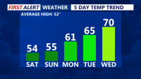
Delmarva will enjoy sunshine and seasonable temperatures this weekend, with highs in the low to mid-50s. Saturday night will be clear and chilly, with lows in the upper 20s to low 30s. Don't forget to set clocks forward an hour for daylight saving time and check smoke detectors. A warming trend begins Monday, bringing highs in the 60s and possibly reaching the low 70s by midweek.
From
To

High pressure remains offshore through Tuesday with mild conditions and a weak cold front bringing light showers Tuesday afternoon, followed by more active weather later in the week

Delmarva faces a chilly, dry start to the weekend, with freezing rain possible Friday night and widespread rain expected through Sunday.

Above-normal temperatures kick off the week, but all attention turns to a potential storm system impacting the region on Thanksgiving and into Friday. Rain is favored for most areas, followed by colder air and brisk conditions into the weekend.

Delmarva will experience a breezy Sunday evening followed by calmer conditions overnight. By Monday morning and afternoon, temperatures will warm slightly ahead of a weak warm front, with dry and seasonable weather dominating.

A weekend of improving weather conditions, today brings partly cloudy and slightly milder temperatures. However, gusty northwest winds will keep things feeling brisk. A dry stretch will persist from Saturday night through early next week, with mild highs in the mid-to-upper 50s and seasonably cool nights. A cold front midweek will introduce cooler air by Wednesday, with the possibility of rain later in the week.

Delmarva will experience improving weather conditions today as a coastal low moves offshore. Temperatures will rise into the mid-to-upper 50s, but coastal flooding concerns will persist due to elevated tides and a full moon. Saturday ushers in sunny skies and breezy conditions with highs in the low-to-mid 60s, kicking off a stretch of above-normal temperatures through early next week.

A coastal low will bring some light rain to parts of Delmarva tonight before moving offshore by Friday morning, ushering in improving conditions. High pressure will dominate the weekend, bringing sunshine and above-normal temperatures, though gusty winds could raise fire weather concerns. A weak cold front will pass on Monday with little impact, followed by continued mild and dry conditions into midweek.

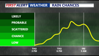
High pressure dominates Delmarva tonight, bringing calm winds, clear skies, and sub-freezing overnight temperatures inland. Rain chances increase late Thursday into Friday as a low-pressure system develops nearby, but precipitation amounts are expected to be light. The weekend promises drier and milder conditions as Canadian high pressure builds into the region, with temperatures climbing into the 60s by Saturday. A weak frontal system may bring isolated showers late Sunday into early Monday, but dry weather returns midweek with above-normal temperatures.

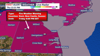
Friday on Delmarva will feature sunny skies and above-normal temperatures, but a Red Flag Warning highlights fire risks due to low humidity and gusty winds; cooler and clear conditions will follow Friday night into early Saturday morning under high pressure.