


DELMARVA - As high pressure continues to dominate Delmarva's weather into Friday, dry and seasonably cold conditions will give way to a more unsettled pattern beginning Friday night. The arrival of two low-pressure systems will bring freezing rain risks overnight Friday and widespread rainfall throughout the weekend.
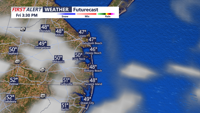
Friday: Chilly Start with Clouds Building
Friday will begin with clear skies and cold temperatures. Morning lows will range from the upper teens inland to the mid-20s near the coast. High pressure will maintain dry weather through the day, with afternoon highs reaching the low to mid-40s. Increasing cloud cover during the afternoon and evening hours will signal the approach of the first low-pressure system.
Friday Night: Freezing Rain Threat
The first system will bring precipitation late Friday night as temperatures at the surface hover in the upper 20s to mid-30s. Southerly flow aloft will create a warm layer above the surface, allowing rain to fall into subfreezing conditions near the ground. This setup increases the likelihood of freezing rain, especially in northern and elevated areas of Delmarva.
While the risk of significant ice accumulation is lower than in regions farther north, untreated bridges, overpasses, and roads could still become slippery. Drivers and pedestrians should exercise caution during the overnight hours. Any freezing precipitation is expected to transition to rain by early Saturday morning as temperatures rise.
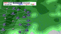
Saturday: Gradual Warm-Up with Scattered Rain
Saturday will see temperatures gradually warming across Delmarva, reducing the chance of freezing precipitation. Highs will climb into the low 40s inland and the low to mid-50s along the coast. However, a slow-moving warm front will bring scattered rain showers throughout the day, with the greatest chances for rain in northern and western areas of the region. Despite the milder temperatures, frequent clouds and rain may dampen outdoor plans.
Sunday: Rainy and Mild
Sunday will bring the most widespread rainfall of the weekend as a deepening low-pressure system moves across the region. Rainfall is expected to intensify during the afternoon and evening, with periods of moderate to heavy rain likely. Highs will be unseasonably warm, reaching the 50s inland and low 60s near the coast. The rain will continue through Sunday night, accompanied by breezy conditions at times.
Rainfall totals through the weekend could approach an inch in some areas, with higher amounts possible in western portions of Delmarva. Ponding on roads and minor flooding in low-lying areas may occur.
Looking Ahead: Early Week Showers and Warmer Conditions
As the rain clears out early Monday morning, a brief period of dry weather will follow before another disturbance arrives midweek. Temperatures will remain above normal through Wednesday, with highs in the 50s for most of Delmarva. A return to more seasonal temperatures is expected late in the week as a trough develops over the eastern U.S.