


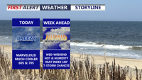
Delmarva starts the week cooler and much drier behind a backdoor cold front, with mainly dry weather expected through Tuesday. Temperatures will quickly rebound by midweek, followed by dangerous heat and humidity Thursday into Friday, along with daily thunderstorm chances from Wednesday through the weekend.
From
To

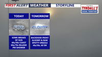
A weak cold front will bring a chilly night and seasonable Tuesday to Sussex County, with most areas staying dry.

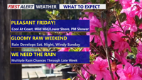
Delmarva will enjoy a pleasant Friday with partly cloudy skies, lighter northeast winds and cooler temperatures compared to Thursday. Temperatures will range from the low to mid 60s at the beaches to the 70s inland, with some lower shore communities nearing 80 degrees. A spotty shower is possible Friday evening into the overnight, but the bigger change arrives this weekend as low pressure brings widespread rain, chilly temperatures and breezy coastal conditions. Rainfall totals from Friday night through Sunday may reach half an inch to slightly over an inch inches across the area, providing beneficial rainfall despite the soggy weekend.


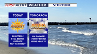
Delmarva will see a mild start today with highs reaching the upper 60s to near 70 and just a slight chance for a light shower. Warmer-than-normal weather continues Thursday with temperatures climbing into the low to mid 70s, but a backdoor cold front brings cooler conditions Friday. The biggest weather change arrives this weekend, when a developing low pressure system is expected to spread widespread rain across the region along with much chillier temperatures.

Delmarva started the day with a cold morning, with many spots away from the coast in the 20s, but sunshine and lighter winds will help temperatures recover into the mid to upper 50s and near 60 this afternoon. Milder air builds in tonight and Wednesday, with highs surging into the upper 60s and low 70s. Even warmer weather arrives Thursday and Friday before a cooler pattern and the chance for beneficial widespread rain return this weekend.

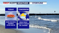
Today marks the third straight day of record-setting heat potential across Delmarva, with highs reaching the upper 80s to around 90 under partly cloudy skies. Dry air, gusty southwest winds, and ongoing drought conditions will also create an elevated fire weather risk. A weak front brings only slight cooling Friday, while a sharper cooldown arrives over the weekend with much-needed rain late Saturday night into Sunday. Early next week turns significantly cooler, with frost or even freeze conditions possible by Monday night into Tuesday morning before temperatures rebound by midweek.


Delmarva stays locked under clouds today as a backdoor cold front keeps temperatures chilly, especially near the beaches. Fog and drizzle develop tonight, then milder air builds in this weekend with partial clearing Saturday afternoon, a chance for showers overnight Saturday into Sunday, and much warmer temperatures arriving early next week.

A stalled front keeps Delmarva dreary and foggy today, with the coolest, foggiest weather hugging the coast while inland areas briefly break into sunshine and warmer temperatures. Fog and drizzle linger into tonight and early Friday, then a backdoor cold front reinforces cooler, cloudier conditions. The pattern flips this weekend as warmer air pushes back in, turning noticeably milder Sunday and especially early next week with a few chances for showers and even a thunderstorm.

Low clouds, leftover fog and a few showers early Thursday give way to a damp, gray stretch into Friday morning.

Clouds stick around, but a mild southwest breeze pushes Delmarva into the mid to upper 50s today, with some inland spots near 60° and gusts 25–30 mph. Tonight stays damp and mild with patchy fog and a spotty sprinkle possible. A backdoor cold front cools some areas Thursday, then rain moves in Thursday night into Friday, with 0.50" to 1.00" possible. The weekend starts quiet and dry, but Sunday night into Monday bears watching for a potential coastal low that could bring rain changing to snow—still uncertain this far out.