


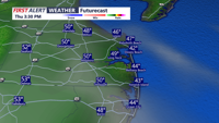
A cool start Thursday will give way to a mild, dry stretch into early Friday as clouds increase along Sussex County’s coastline.
From
To


Clear skies late Wednesday evening will turn into a cooler, partly sunny Thursday for Sussex County’s beach towns, with a wetter pattern expected to arrive Friday into the weekend.

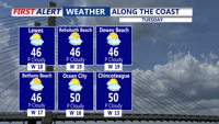
Clouds and warmer temperatures dominate Tuesday, with only a small chance of rain late before clearing and breezy conditions arrive by early Wednesday.


Thunderstorms and heavy rain Thursday will clear out by early Saturday, bringing drier, seasonable weather to Sussex County and the Atlantic coast of the Delmarva Peninsula.


From Wednesday morning through early Friday, Sussex County beach towns will experience cooler-than-normal conditions, with sunshine giving way to clouds and a chance for late showers.

Beach communities in Sussex County will see cooler-than-normal temperatures and mostly dry skies through late Thursday, with only a slight chance of showers as a cold front approaches.


From Wednesday morning through early Friday, beachgoers can expect warm temperatures, light breezes, and mostly dry weather across coastal Sussex County.


After days of relentless thunderstorms dumping more than six inches of rain since the beginning of the month across parts of Sussex County, we are enjoying a quieter weekend. However, patchy fog and muggy nights will persist, and a cold front approaching early next week may renew the threat of showers and thunderstorms.


High pressure offshore will bring dry, hazy, and seasonably warm conditions to Delaware’s beach towns through late Wednesday before unsettled weather approaches later in the week.


Light rain will continue into Wednesday with periods of steady showers and a chance for thunderstorms, especially across southern Delaware, keeping temperatures cooler through midweek.