


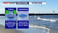
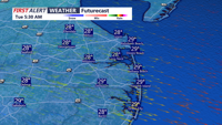
Delmarva turns sharply colder today with temperatures 20 to nearly 30 degrees below yesterday’s levels, gusty winds, and even the chance for a passing evening flurry. The chilly stretch continues through midweek before temperatures gradually rebound, leading to a much milder first weekend of spring with highs climbing into the 60s and 70s.
From
To


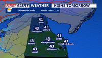
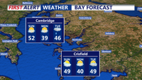
Colder-than-normal temperatures have settled across Delmarva, with highs ranging from the mid-30s to low 40s. The chill deepens by Thursday and into the weekend, as an arctic cold front approaches. While light snow is possible Friday, more impactful snow squalls and dangerously cold wind chills are expected Friday night into Saturday. Gusty winds behind the front may reach 50 mph, especially near the coast.

Clear and bitterly cold conditions Sunday night will give way to slightly milder but still dry weather Monday across Sussex County.


Winds ease late Thursday as cold temperatures persist into Friday with improving skies and no expected precipitation in Sussex County.

Sussex County will see diminishing winds Tuesday night, a cold start Wednesday with a chance of early flurries, then partial clearing and slightly milder afternoon temperatures.

Strong winds and cold temperatures persist Tuesday before easing overnight into early Wednesday in Sussex County.

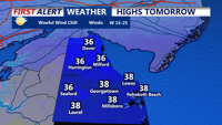
A strong cold front ushers in damaging wind gusts and frigid temperatures through Tuesday evening in Sussex County.


Mild temperatures and scattered showers move through Delmarva today ahead of a strong cold front, followed by gusty winds and a return to winterlike cold through the week.

Gusty winds and mild afternoon temperatures Sunday are followed by clearing skies and a sharp temperature drop by early Monday.

A cold late Monday evening gives way to a mostly sunny but still chilly Tuesday, with no precipitation expected.