


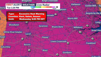
Isolated showers or storms may arrive around dawn Wednesday before Sussex County sees a more unsettled, humid day with additional thunderstorm chances.
From
To

Delmarva will enjoy a beautiful and seasonable day today, with highs in the low 80s inland and low 70s along the coast. Humidity begins to return tonight, setting the stage for scattered showers and storms Wednesday and Thursday. Dangerous heat is likely late this week, especially Thursday and Friday, before a cold front brings some relief into the weekend.

Coastal Sussex County and Ocean City should stay dry from early Tuesday through early Wednesday as temperatures begin to climb.


Delmarva starts the week cooler and much drier behind a backdoor cold front, with mainly dry weather expected through Tuesday. Temperatures will quickly rebound by midweek, followed by dangerous heat and humidity Thursday into Friday, along with daily thunderstorm chances from Wednesday through the weekend.


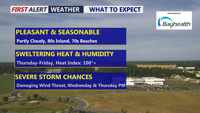
Dangerously hot and humid conditions will continue across Delmarva Wednesday before a slow-moving cold front brings showers and thunderstorms Thursday, raising the risk of flash flooding. Much cooler, breezy, and wetter conditions are expected Friday, followed by a pleasant, drier weekend and early next week.


Delmarva will experience humid, foggy nights and a stretch of unsettled weather through midweek. Beginning Sunday night, areas of mist and patchy fog will develop, especially along the coast. A cold front approaching late Monday will trigger showers and thunderstorms, with the primary concern being heavy rain and flash flooding. While the severe thunderstorm risk is low, locally gusty winds cannot be ruled out. The front is expected to stall through Wednesday, keeping rain chances high before heat and humidity surge again later in the week.

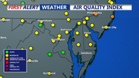
Sussex County residents face dangerously high heat and humidity through Wednesday evening, with temperatures and heat index values among the hottest in over a decade.

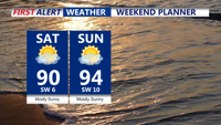
Starting Saturday, high pressure will usher in increasingly hot and humid weather across Delmarva. While Saturday remains manageable with highs near 90 and dewpoints in the mid-60s, the real danger sets in by Sunday with heat indices nearing triple digits. You should prepare for heat advisories and take safety precautions through at least Wednesday.

DELMARVA - Hot and humid conditions will persist with high temperatures in the low to mid-90s and heat index values ranging from 100 to 110 de…

Expect dangerously hot and humid conditions to persist Tuesday evening with potential severe thunderstorms. Wednesday will remain warm and humid, with temperatures slightly cooler but still uncomfortable.