• Updated

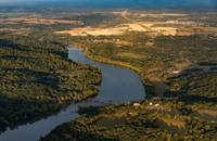
More than $7.1 million in federal conservation funding is headed to Delaware to support projects across the state’s portion of the Chesapeake Bay watershed. The funding aims to support water quality improvements, habitat restoration and community stewardship.

Delmarva warms up today as a warm front lifts through, pushing highs into the mid to upper 40s with partly to mostly cloudy skies. A light southerly breeze increases tonight with a small chance of a stray sprinkle, but most spots stay dry and above freezing. Wednesday stays in the 40s but turns noticeably breezy ahead of a moisture-starved cold front. Cooler, breezy conditions follow Thursday and Friday, then Valentine’s Day kicks off the weekend with sunshine and a springlike feel. Late Sunday into early Monday, a storm system could bring precipitation—details still uncertain this far out.

A coastal low moving north from the Carolinas is bringing scattered showers, gusty northeast winds and dangerous surf conditions to the Delmarva Peninsula Tuesday. The system will weaken into Wednesday, followed by a cold front Friday and a stretch of dry, pleasant weather into the weekend and early next week.

A coastal low will produce unsettled weather through midweek with mostly cloudy skies, periods of showers, and gusty northeast winds. Highs will stay in the upper 60s to low 70s with lows in the 50s to 60s. Rain will be heaviest Tuesday night into Wednesday morning, bringing 1 to 2 inches of precipitation and occasional thunder. Conditions will improve by Thursday, with drier and warmer weather returning late week and highs climbing into the 80s before a dry front cools temperatures over the weekend.

  • Updated

The holiday with activist roots is celebrated on the first Monday of September, creating a three-day weekend that marks the unofficial end of summer.

Delmarva faces moderate coastal flooding Friday evening as we deal with residual impacts of Hurricane Erin, with warnings in effect through early Saturday. Skies will clear overnight with lows in the 50s inland and low 60s near the coast. Saturday brings sunshine and highs in the low to mid 80s, followed by rising humidity ahead of a cold front Sunday into Monday that could spark scattered showers and thunderstorms. Cooler, drier air returns by midweek, with highs in the 70s and lows in the 50s.

  • Updated

It was a difficult and sweltering week across the Delmarva Peninsula, marked by tragic drownings, heat-related concerns, and jellyfish activity along the coast.