


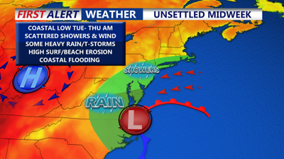
DELMARVA -- An unsettled start to the week, with showers, gusty winds, high surf, beach erosion and cooler-than-normal temperatures before conditions improve heading into the weekend.
Today, onshore flow will keep highs in the mid to upper 70s. Skies will remain mostly cloudy tonight as a coastal low off the Carolinas drifts north, bringing increasing chances of showers overnight. Lows will fall into the mid-50s to mid-60s, with winds along the coast gusting between 20 and 30 mph, MODERATE rip current risk, waves 2 to 4 feet.

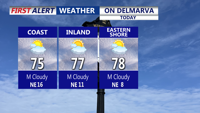
Clouds increase ahead of a coastal low that will impact that region beginning tonight. Highs today mid to upper 70s, breezy 10 to 20 mph winds out of the northeast.
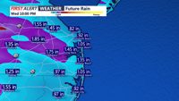
A coastal storm will keep the region damp and breezy through Wednesday. Showers are expected to become more widespread Tuesday morning and peak Tuesday night into Wednesday morning, with rainfall totals around 1 to 2 inches and locally higher amounts possible. The rain will come in periods rather than a steady all-day event, with some thunder possible due to elevated instability. No severe storms are expected, but stronger showers may produce brief gusts up to 40 mph.

Rainfall totals beginning Tuesday-Thursday AM, on the order of 1 to 2 inches, some locally higher amounts.
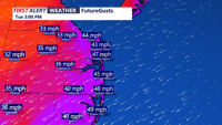
Persistent northeast winds will also be a factor, especially along the coast, where gusts could reach 40 to 50 mph Tuesday.

Tuesday wind gusts at the coast 45-50 MPH + out of the northeast.
Highs will remain in the upper 60s to low 70s, with lows in the mid-50s to mid-60s through midweek. HIGH rip current risk Tuesday, waves 4 to 6 feet for the DE Beaches, 5 to 9 feet Ocean City to Chincoteague. Beach erosion is likely through midweek, as well as coastal flooding concerns.
Conditions are expected to improve by Thursday as the coastal low moves out to sea. Temperatures will rebound to near 80 degrees Thursday and into the mid-80s Friday ahead of a dry cold front expected to sweep through late Friday or Saturday. Highs will drop back into the 70s over the weekend under mostly sunny skies, with lows falling into the low to mid-50s behind the front.