


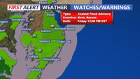
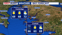
Delmarva will experience improving weather conditions today as a coastal low moves offshore. Temperatures will rise into the mid-to-upper 50s, but coastal flooding concerns will persist due to elevated tides and a full moon. Saturday ushers in sunny skies and breezy conditions with highs in the low-to-mid 60s, kicking off a stretch of above-normal temperatures through early next week.

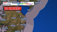
A coastal low will bring some light rain to parts of Delmarva tonight before moving offshore by Friday morning, ushering in improving conditions. High pressure will dominate the weekend, bringing sunshine and above-normal temperatures, though gusty winds could raise fire weather concerns. A weak cold front will pass on Monday with little impact, followed by continued mild and dry conditions into midweek.

A shift to a southerly flow will bring warmer temperatures and mostly dry conditions to Delmarva on Monday and Tuesday, with highs reaching the low to mid-70s before a weak cold front approaches midweek.

A ridge of high pressure will keep Delmarva dry and mild through Monday, with warmer temperatures on the way as a southerly flow develops. Highs will reach the low to mid-60s, making for a pleasant start to the week, but changes are ahead with a cold front arriving midweek.

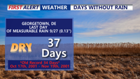
A sunny, dry weather pattern will persist over Delmarva, extending a 28-day streak without measurable rainfall. Friday brings clear skies and mild temperatures, but breezy conditions on Saturday may elevate fire weather risks. Little to no rain is expected from weak frontal systems this weekend, and high pressure will maintain dry conditions into next week. Temperatures will gradually warm, reaching the 70s by midweek.

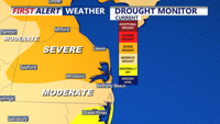
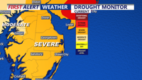
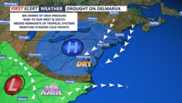
High pressure will continue to dominate Delmarva’s weather through the weekend and into next week, bringing dry conditions and seasonable temperatures. The Delmarva Peninsula remains in a severe drought, now marking 27 consecutive days without measurable rainfall. A cold front passing through on Friday night and Saturday will bring cooler air, but little chance of precipitation. Frost may develop in some areas overnight as temperatures dip into the 30s, while gusty winds and dry conditions increase fire weather concerns.

A strong cold front moves offshore Thursday morning, bringing cooler temperatures and gusty winds through the day, followed by dry and chilly conditions into Friday, with another cold front approaching Friday night.

A cold front will move through Delmarva late Wednesday night into early Thursday, bringing cooler temperatures, gusty winds, and dry conditions. Expect temperatures to drop to near-average levels by Thursday afternoon with fire weather concerns due to the dry air and strong winds.

The dry weather persists across the Delmarva region, with warm temperatures and low humidity expected through late Monday and into Tuesday. Near-record highs are possible on Tuesday before moisture begins to gradually increase ahead of a mid-week cold front.

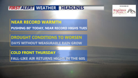
High pressure will dominate Delmarva's weather through Wednesday, bringing clear skies, warm afternoons, and cool nights. Temperatures will rise near record highs by Tuesday, followed by a significant cold front late Wednesday night into Thursday morning. Cooler, breezy conditions will settle in for Thursday and Friday. Another cold front is expected on Saturday, followed by high pressure and seasonal weather for the weekend.