


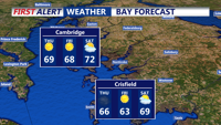


DELMARVA - As Thursday morning begins, a strong cold front will already be offshore, leaving behind cooler air and gusty north-northwest winds. Skies may start out with a few lingering clouds, but by mid-morning, conditions will clear, bringing plenty of sunshine. Despite the sunny skies, temperatures will only rebound into the 60s for most of the area, which is close to seasonal averages. The winds will be gusty, especially through early afternoon, with gusts reaching 25 to 30 mph at times before gradually easing later in the day. A much drier air mass will filter in during the afternoon, with dew points dropping into the 30s, which will elevate fire weather concerns across the region.
By Thursday night, high pressure will build into the area, resulting in clear skies and light winds. With the cooler air in place, temperatures will drop significantly overnight, with lows dipping into the upper 30s to low 40s. Friday will see continued cool and dry conditions as high pressure slides offshore. Temperatures will once again rise into the mid-60s, under sunny skies. Dew points will remain low, in the 30s, keeping the air dry and crisp.
A weak cold front will approach Friday night, bringing a slight chance for a few sprinkles or light showers, but significant rainfall is not expected due to the dry atmosphere. Most areas will stay dry as the front passes, with overnight lows ranging from the 40s to low 50s. Despite the frontal passage, little cold air will follow behind it, and Saturday will remain mild with highs in the 60s to around 70 under sunny skies.