


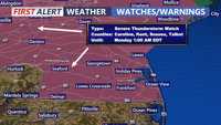
A Severe Thunderstorm Watch is in effect until 1:00 AM Monday. Conditions are favorable for damaging winds and heavy rain.
From
To

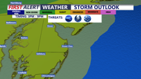
Delmarva will see a hot, muggy, and windy Thursday with scattered severe storms possible late this afternoon into the evening. Friday stays unsettled with lingering showers and storms before a much brighter Father’s Day weekend.

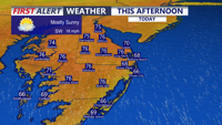
Delmarva will enjoy a mostly sunny and breezy day today with highs in the mid 70s and strong southerly gusts up to 35 to 40 mph. Showers arrive late this evening and continue overnight, with a few isolated thunderstorms possible, though severe weather is not expected. A brief unsettled stretch gives way to warmer, drier conditions by the weekend, with heat building into early next week.

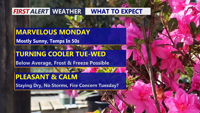
A limited fire weather risk continues into Tuesday evening for inland Sussex County before showers arrive Wednesday with little severe weather threat.

Showers and an isolated thunderstorm are possible in Sussex County late Wednesday evening into early Thursday before conditions turn drier and breezy through Thursday evening.

Sussex County starts Wednesday mainly cloudy and quiet before showers and a few stronger storms arrive late in the day and continue into early Thursday.

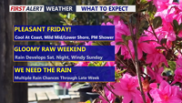
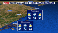
Delmarva will enjoy a pleasant Friday with partly cloudy skies, lighter northeast winds and cooler temperatures compared to Thursday. Temperatures will range from the low to mid 60s at the beaches to the 70s inland, with some lower shore communities nearing 80 degrees. A spotty shower is possible Friday evening into the overnight, but the bigger change arrives this weekend as low pressure brings widespread rain, chilly temperatures and breezy coastal conditions. Rainfall totals from Friday night through Sunday may reach half an inch to slightly over an inch inches across the area, providing beneficial rainfall despite the soggy weekend.

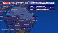
Today starts a much cooler stretch across Delmarva with mostly cloudy skies, highs in the mid 50s, and gusty winds. The biggest concern is tonight, when a widespread freeze is expected inland with a Freeze Warning in effect from midnight to 9 AM Tuesday. After a chilly Tuesday, temperatures rebound into the 60s and 70s by mid to late week before cooler weather and a better chance of rain return for the weekend.

Delmarva will enjoy plenty of sunshine Monday with highs in the upper 50s to near 60, but breezy west-northwest winds will keep it feeling cool. A reinforcing shot of cold air arrives Tuesday, bringing gusty winds, elevated fire concerns, and a growing risk of freezing temperatures by Wednesday morning, with patchy frost possible again Thursday.


Near record warmth this afternoon, Easter Sunday becomes rainy with storms possible.