


From early Wednesday through early Friday, Sussex County will face repeated rounds of showers and thunderstorms along with oppressive heat and high humidity.

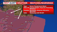
Periods of showers and thunderstorms will affect Sussex County from late Tuesday evening through late Wednesday evening, bringing locally heavy rain, warm and humid conditions, and the potential for isolated strong storms.

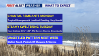
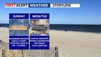
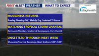
Beginning Sunday night, Delmarva will enter a period of high humidity and unsettled weather. The remnants of Tropical Storm Chantal will bring rounds of showers and thunderstorms Monday and Tuesday, with locally heavy rainfall and potential flash flooding. Severe storms possible Tuesday afternoon/evening. A stalled cold front will keep the region stormy through late week, while oppressive heat and humidity push heat index values to near 106 degrees.

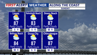
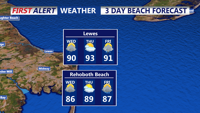
Seasonably warm and increasingly humid conditions will build across Delmarva Sunday afternoon as high pressure shifts offshore. Highs will reach into the 80s to near 90, with an isolated thunderstorm possible by evening. By Monday and into midweek, a tropical air mass will set the stage for daily rounds of showers and thunderstorms. Some storms could produce heavy rainfall, localized flooding, and dangerous heat indices approaching 100 degrees inland.

High pressure offshore will usher in warmer and more humid air over Delmarva on Sunday, with highs climbing into the 80s to near 90 and muggy nights returning. While most areas should remain dry through Sunday, an isolated thunderstorm cannot be ruled out. By Monday and into the rest of the week, tropical moisture and unstable conditions will bring daily chances for showers and thunderstorms, some capable of heavy rainfall and localized flooding.

Pleasant weather will continue Saturday night across Delmarva, with partly cloudy skies and lows in the 60s. As high pressure shifts offshore, temperatures and humidity will climb Sunday into Monday. By early next week, a tropical and unsettled pattern will bring daily chances of showers and thunderstorms, heavy rainfall, and heat indices over 100 degrees.

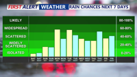
High pressure will maintain calm and seasonable weather across Delmarva through the holiday weekend. Temperatures will climb into the upper 80s and low 90s by Sunday, with humidity gradually increasing. By early next week, a tropical, unsettled pattern is expected to develop, bringing daily chances for showers and thunderstorms along with oppressive heat and potential localized flooding.

A strong cold front is set to move through Delmarva this afternoon and evening, with periods of heavy rain, strong winds, and a risk of severe thunderstorms.

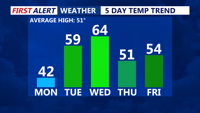
Monday brings plenty of sunshine to Delmarva but remains cold, with highs in the low 40s and wind chills in the 20s. A warming trend begins Tuesday as high pressure shifts offshore, leading to gusty winds and increasing humidity. A strong cold front arrives Wednesday into early Thursday, bringing periods of rain, gusty winds, and possibly thunderstorms. After a brief return of high pressure, another system could impact the region next weekend.

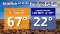
Delmarva experienced a significant temperature plunge from Saturday to Sunday, with a drop of 45 to 50 degrees. High pressure dominates through Tuesday before a strong cold front arrives midweek, bringing rain, gusty winds, and the potential for severe thunderstorms. Temperatures will rebound slightly by late week, with another system possible next weekend.