


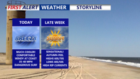
High pressure moving in from the north will push Hurricane Humberto and Imelda out to sea, bringing sunny skies and seasonable temperatures to Delmarva. Coastal winds and dangerous rip currents, however, remain a concern through the week.
From
To

Sussex County will see mostly dry conditions through Wednesday with patchy fog, increasing high clouds, and a cool-down midweek as a strong cold front moves through.

Sussex County will see mostly clear skies with patchy fog late Sunday, followed by increasing clouds and mild temperatures Monday as high pressure holds firm.

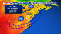
Delmarva will experience a warm, mostly sunny Friday with highs in the mid to upper 80s before cooler air and high pressure settle in for the weekend, bringing seasonable temperatures and limited chances for showers along coastal areas.

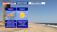
Weak low pressure is moving off the Delmarva coast today, giving way to clearing skies and mild conditions. Warm temperatures are expected Friday ahead of a dry cold front, followed by a cooler and dry weekend under Canadian high pressure.

High pressure will keep Sussex County dry with mostly sunny skies and seasonable temperatures from Thursday through early Saturday.

Clouds and showers will taper off Wednesday evening as high pressure brings clearer skies and seasonable temperatures through Friday.

High pressure will keep Delmarva sunny and mild Sunday, with highs in the mid to upper 70s and a low rip current risk. Tranquil weather continues through Labor Day, but rain chances increase by Thursday as a cold front approaches.

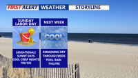
High pressure will keep Delmarva under mostly sunny skies Sunday, with highs in the mid to upper 70s and a low rip current risk. The tranquil weather pattern will carry through Labor Day, but a chance of showers develops by Thursday as a cold front approaches.

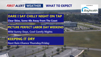
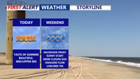
Clear skies and comfortable temperatures will carry Delmarva through the holiday weekend, with mostly sunny conditions expected into Labor Day. A shift in the weather pattern by midweek could bring showers, but cooler, dry air is forecast to return by next weekend.