


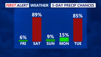
A developing low-pressure system will bring a mix of snow, rain, and freezing rain to the region from Saturday into early Sunday before conditions improve later in the day.
From
To

A second cold front will bring breezy conditions late Thursday into Friday before a high-pressure system briefly settles over the region.

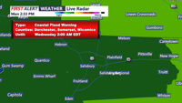
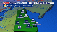
High pressure from the Canadian Maritimes will influence Delmarva's weather as it sags into the region, while low pressure and a cold front approach from the west. Expect showers and cooler temperatures tonight, with coastal flood warnings and advisories in effect through Tuesday.

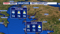
A coastal low will bring scattered showers and cloudy conditions to Delmarva on Wednesday, with drier weather expected by early Thursday.

The Delmarva region will experience above-normal temperatures and isolated thunderstorms on Thursday, followed by a stronger weather system moving in late Friday through the weekend.

A weak front brings isolated thunderstorms this afternoon, followed by a clear and quiet night with patchy fog possible and temperatures in the upper 60s to low 70s.

Wednesday brings scattered showers and thunderstorms to Delmarva as a shortwave trough passes through, while temperatures climb into the 90s. The trend towards drier and hotter weather continues into the weekend, with potential heat advisories.

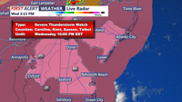
Delmarva faces severe thunderstorms, heavy rain, and gusty winds from this afternoon through the night, as a slow-moving cold front brings significant weather risks.

Expect dangerously hot and humid conditions to persist Tuesday evening with potential severe thunderstorms. Wednesday will remain warm and humid, with temperatures slightly cooler but still uncomfortable.
A stalled frontal boundary near the I-95 corridor will influence weather conditions on the Delmarva Peninsula over the short term, bringing periods of rain and potential flash flooding.