


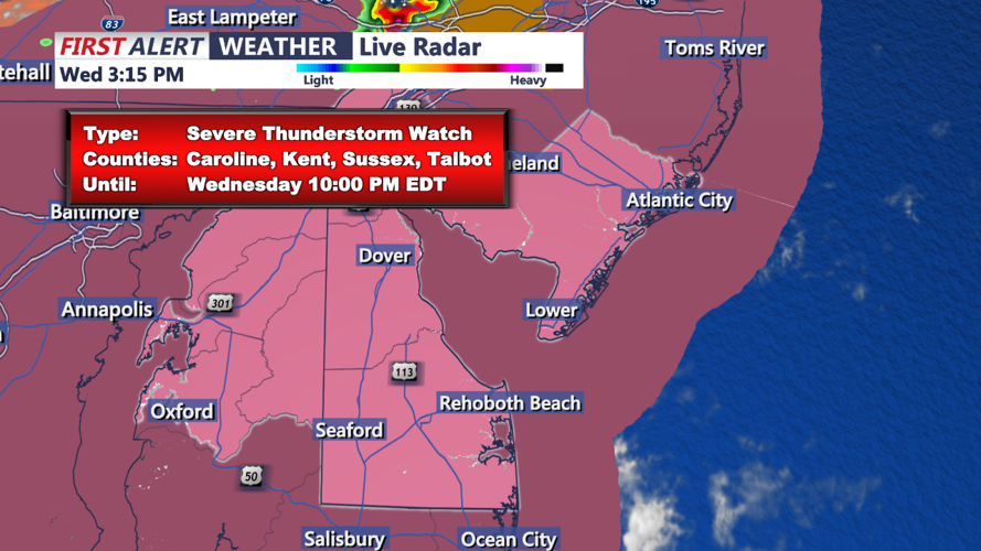


DELMARVA - For the storms later tonight, a slow-moving cold front will create a marathon of severe weather and hydro concerns beginning early afternoon through at least the evening hours into the overnight. Abundant instability and PWAT values over 2 inches will fuel the potential for training thunderstorms across the region. Much of the storms during the afternoon will stay north and west of the I-95 corridor, with storms in the evening and nighttime largely impacting areas near and south and east of the I-95 corridor.
The SPC now has our entire area in a Slight Risk of severe weather (level 2 out of 5). The biggest threat looks to be damaging winds given deep layer shear around 25 to 30 knots and ML CAPES of 1500-2000+ j/kg. The WPC has a Slight Risk for excessive rainfall for the urban corridor with a Marginal Risk for the rest of the CWA.
Scattered thunderstorms are expected to continue through the first half of tonight ahead of the advancing cold front. Heavy rain and locally gusty winds will be the main threats as the line of storms works its way through the area. Storms should eventually give way to just some residual showers before tapering off from northwest to southeast overnight. Low temps will fall in the upper 60s to low 70s.
The cold front should fully cross through the region by Thursday morning but will begin to slow down as it passes to our south and east. While the northern half of the area will begin to see some clearing, the southern half of the area (especially near the coast) will see cloud cover linger throughout the day.
