


Sussex County, Delaware, and the Ocean City, Maryland, area can expect showers and isolated thunderstorms late Wednesday evening into early Thursday, followed by cooler, cloudy conditions Thursday.
From
To

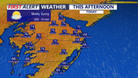
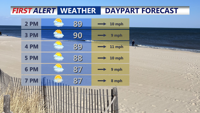
Delmarva will enjoy a mostly sunny and breezy day today with highs in the mid 70s and strong southerly gusts up to 35 to 40 mph. Showers arrive late this evening and continue overnight, with a few isolated thunderstorms possible, though severe weather is not expected. A brief unsettled stretch gives way to warmer, drier conditions by the weekend, with heat building into early next week.

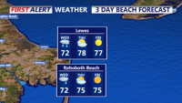
Sussex County will start Wednesday mainly dry and mild before showers arrive by evening and continue into early Thursday morning.

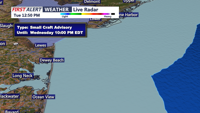
Sussex County stays mainly quiet late Tuesday night into much of Wednesday before showers and a few isolated thunderstorms move in Wednesday evening.


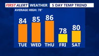
Today stays warm and sunny across Delmarva, but temperatures step down from yesterday’s record highs. Cooler air arrives near the coast Saturday as a backdoor front pushes in, while inland areas stay milder. Minor tidal flooding is expected along the Delaware coast and Delaware Bay Saturday evening into Saturday night, followed by showers, a few thunderstorms, and a sharp cool down late Saturday night into Sunday. Much colder air settles in early next week, with widespread frost or freeze conditions likely Monday night into Tuesday morning.


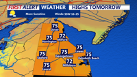
High pressure brings mostly dry and warm weather to Delmarva Friday with highs in the upper 70s to low 80s. Clouds increase Friday night into Saturday as a weak upper-level system approaches, bringing periods of rain late Saturday into early Sunday. Temperatures remain seasonable through the weekend, tropical moisture may impact the region early next week.

Delmarva will experience unseasonably warm and humid conditions through Thursday, with highs in the upper 70s to mid-80s and dew points in the 70s. Scattered showers and isolated severe storms are possible Thursday PM, with the Storm Prediction Center placing the entire peninsula under a marginal risk for damaging winds. Rainfall totals could reach 1 to 2 inches before a cold front moves through by late week.

Sussex County will see periods of showers, breezy winds, and near-normal temperatures from late Tuesday into Thursday before conditions turn drier.


Delmarva will see dangerous heat and humidity Friday, with heat index values reaching up to 108 degrees and a Heat Advisory in effect. A cold front arriving late Friday will bring a chance of isolated storms, mainly north of Sussex County, before lingering near the region through Saturday and lifting north as a warm front Sunday. The weekend will be unsettled but not a total washout, with additional storm chances Sunday night. High pressure returns Monday before another frontal system arrives midweek.

Sunday will be hot and humid across Delmarva with temperatures rising into the upper 80s and low 90s and heat index values between 100 and 104 degrees. A cold front approaching from the northwest could trigger isolated storms late in the day, some of which may become severe. After the front moves through, high pressure will bring more comfortable and dry conditions through Wednesday before heat and humidity return late in the week.