


Mostly sunny, breezy and comfortable conditions are expected today, followed by a dry and increasingly warm stretch through Saturday.
From
To

Delmarva will see a mostly sunny and seasonably warm day today, with inland highs in the mid 80s and cooler conditions along the coast. A slow-moving cold front will bring increasing chances for showers and thunderstorms late Friday into Saturday before drier weather returns Sunday. Heat and humidity are expected to build again by the middle and latter part of next week.


Today stays warm and sunny across Delmarva, but temperatures step down from yesterday’s record highs. Cooler air arrives near the coast Saturday as a backdoor front pushes in, while inland areas stay milder. Minor tidal flooding is expected along the Delaware coast and Delaware Bay Saturday evening into Saturday night, followed by showers, a few thunderstorms, and a sharp cool down late Saturday night into Sunday. Much colder air settles in early next week, with widespread frost or freeze conditions likely Monday night into Tuesday morning.

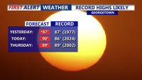
Delmarva’s early taste of summer continues today as temperatures climb into the upper 80s to low 90s under mostly sunny skies. After Georgetown tied its record high of 87 yesterday, more record highs are possible today with southwest winds at 10 to 15 mph. The warmth holds through Thursday before a weak front slips through late Thursday night, followed by a cooler but still mild Friday and Saturday. A stronger cold front arrives Sunday with scattered showers and thunderstorms possible late, then much cooler air settles in early next week with highs dropping into the 50s and 60s and even a chance for frost by Tuesday morning.

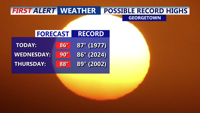
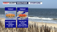
Today brings unseasonably warm weather to Delmarva with highs in the mid 80s under mostly sunny skies, though areas near the bay and ocean will stay a bit cooler in the upper 70s to low 80s. Georgetown and Salisbury could come close to their daily record highs of 87 degrees. The warmth continues tonight and intensifies Wednesday, when record highs are likely as temperatures approach 90. Conditions stay well above normal through the weekend before shower and thunderstorm chances return Sunday ahead of a strong cold front. Much cooler air arrives next week with highs falling back into the 50s and 60s.

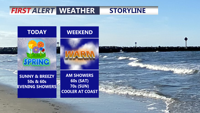
Today officially began spring at 10:46 this morning, and Delmarva is enjoying mostly sunny skies, mild temperatures, and increasing southwest winds gusting 30 to 35 mph. Clouds will build this evening ahead of a quick-moving system bringing light showers overnight into early Saturday, with rainfall totals staying under a quarter inch and showers ending by around 8 a.m. Saturday. The weekend stays mild, with highs in the 50s and 60s Saturday and well into the 70s inland Sunday, before a stronger cold front arrives Monday with showers, gusty winds, and much colder air to start next week.

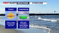
Delmarva turns noticeably warmer today with temperatures running about 10 to 13 degrees above yesterday’s levels. Mostly sunny skies will help highs reach the upper 40s to low 50s, followed by a mostly clear and chilly night with lows in the low to mid 30s. Spring officially arrives at 10:46 Friday morning, and even milder air is on the way with low 60s Friday, 60s Saturday, and some areas near 70 by Sunday before rain chances return late in the weekend.

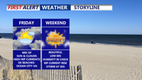
Friday will bring a mix of sun and clouds to the region with highs in the upper 70s to low 80s, but a high risk of rip currents will persist along the Delaware Beaches through Ocean City and Assateague Island. The dangerous surf, driven by onshore flow and a distant storm, is expected to continue into the weekend. High pressure will keep the area mainly dry and mild through Sunday, with lighter winds and slightly warmer temperatures Saturday. Sunday will be sunny and seasonable before heat and humidity build early next week, with widespread 90s and a chance for storms by midweek.


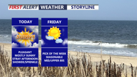
DELMARVA -- A pleasant Memorial Day as high pressure builds in from the north and west, clearing skies this afternoon. Expect mostly sunny ski…

Delmarva will enjoy a mild, mostly sunny weekend as a weak front brings pleasant fall weather. Saturday’s highs will reach the upper 70s, with cooler temperatures expected overnight. Sunday will remain sunny and warm, with temperatures near 80 but a cold front on Monday will introduce cooler, breezy conditions for the start of the work week.