


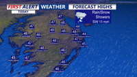
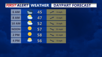
Delmarva dries out this afternoon after morning showers, with partly sunny skies, gusty southwest winds, and highs in the upper 40s to near 50. Tonight stays above freezing in the mid to upper 30s. A weak system brings a chance for light showers Thursday late afternoon through Thursday night, followed by a pleasant, partly cloudy Friday. The weekend looks outstanding, peaking Saturday with sunshine and highs in the upper 50s to near 60, then cooling a bit Sunday behind a backdoor cold front. Early next week bears watching for another system that could bring a wintry mix, but confidence is still low.
From
To

Breezy conditions build early Wednesday as a cold front moves through, followed by a quieter and colder Wednesday night into early Thursday.


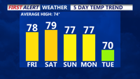
A few morning showers, otherwise sunshine today allowing afternoon highs to reach the mid to upper 60s today and Sunday. We'll see a better chance of showers Sunday. Then a taste of winter early next week.


High pressure continues to move offshore this evening, as southerly winds pull in warmer air, allowing afternoon highs to reach the mid to upper 60s this weekend. We'll see a better chance of showers Sunday. Then a taste of winter early next week.

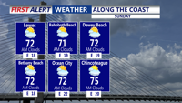
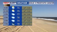
Sunday’s weather will be similar to Saturday's, with high pressure drifting slightly southeast. This will maintain an onshore flow and the possibility of an isolated shower near the coast.

Tonight a backdoor cold front will slip south into the area, shifting winds out of the north and allowing cooler air to move in. Overnight lows will dip into the upper 50s to low 60s.

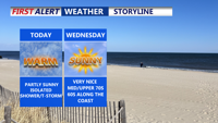
Patchy fog gives way to partly sunny skies and warm temperatures. A mix of isolated showers and storms will punctuate the rest of the week as multiple upper-level systems move through the region, bringing cooler temperatures and increased rain chances into the weekend.

Warm and mostly dry conditions will persist through Wednesday on Delmarva, with near-record high temperatures possible. A cold front will move into the area late Wednesday night, bringing cooler temperatures and a chance of showers by Thursday.

Delmarva's weather for the weekend will feature increased cloud cover on Friday as a weakening ridge gives way to an approaching cold front. Friday night into early Saturday could bring isolated showers, but overall, the weekend will remain mostly dry with cooler temperatures under the influence of high pressure. A second cold front is expected to approach on Sunday, potentially bringing more showers late Sunday night into Monday morning.

Delmarva residents can expect a mix of misty mornings, low clouds, and scattered showers starting Sunday. Highs will range from the mid to upper 70s, with some inland areas possibly reaching 80 degrees. The weather pattern will remain unsettled due to a stalled front and the remnants of tropical moisture, leading to continued cloudy and damp conditions into midweek. Occasional rain showers are likely, especially Monday night into Tuesday, with the potential for isolated downpours. A cold front will move through by Wednesday, bringing slightly cooler but generally dry conditions for the latter part of the week.