


Scattered storms may bring damaging winds and flooding before drier air arrives.
From
To


Severe storms and flooding remain possible through Wednesday night.


Sussex County will face its hottest weather of the week Wednesday before a weak front brings slightly lower humidity by Thursday morning.

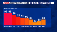
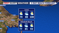
Dangerous heat and humidity will grip Sussex County on Wednesday, with temperatures climbing into the upper 90s and heat index values reaching 100 to 105 degrees.


Delmarva will see a cloudy and humid day today as a warm front lifts north, bringing scattered showers and thunderstorms late this afternoon into tonight. A few storms could produce damaging wind gusts and heavy downpours. Dangerous heat and humidity build Thursday and Friday, with heat index values potentially reaching 95 to 104 degrees and additional severe storm chances.

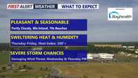
Delmarva will enjoy a beautiful and seasonable day today, with highs in the low 80s inland and low 70s along the coast. Humidity begins to return tonight, setting the stage for scattered showers and storms Wednesday and Thursday. Dangerous heat is likely late this week, especially Thursday and Friday, before a cold front brings some relief into the weekend.

Coastal Sussex County and Ocean City should stay dry from early Tuesday through early Wednesday as temperatures begin to climb.


High pressure will keep coastal Sussex County and Ocean City mainly dry through Tuesday evening before heat and storm chances build later in the week.


Delmarva will begin the holiday weekend with raw, breezy, and damp conditions today as spotty showers move across the peninsula. Temperatures will stay in the upper 50s to low 60s with east winds gusting up to 30 mph. A high rip current risk and cold ocean water will make beach and surf conditions dangerous today and tomorrow. Rain becomes steadier Saturday into Saturday night, with beneficial rainfall expected before showers taper Sunday. Memorial Day looks somewhat warmer, but showers may still linger at times.


Sussex County can expect a cooler Thursday with clouds, a few lingering showers early and another brief shower possible during the afternoon before drier weather settles in Thursday night.