






DELMARVA - Wednesday morning starts warm and increasingly humid, with temperatures quickly rising after sunrise. Morning readings in the 70s will climb into the 90s by midday as strong July sunshine and a westerly wind push the heat higher.
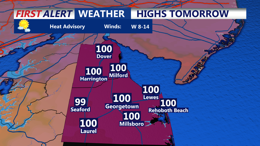
Afternoon highs are expected to reach the mid to upper 90s across inland communities, including Georgetown, Seaford, Millsboro and Laurel. Coastal areas will offer little relief, with temperatures also climbing well into the 90s near Lewes, Rehoboth Beach, Bethany Beach and Fenwick Island.
Heat index values are expected to reach 100 to 105 degrees. A west wind of 10 to 15 mph will hold the sea breeze close to the immediate shoreline and prevent cooler ocean air from spreading inland.
Hazy skies are possible as smoke from Canadian wildfires drifts across the region. The smoke could slightly reduce the highest temperatures, but dangerous heat and humidity will remain the primary concern.
Residents should limit strenuous outdoor activity during the afternoon, drink plenty of water and take frequent breaks in air-conditioned locations. Anyone attending outdoor events or visiting the beaches should watch for signs of heat exhaustion, including dizziness, nausea, weakness and heavy sweating.
A mostly dry cold front will move through Wednesday evening and overnight. No widespread rain is expected in Sussex County, although a stray shower cannot be completely ruled out.
Wednesday night will remain warm, with lows falling into the low to mid-70s. By early Thursday morning, humidity should begin to ease slightly, but temperatures will remain above normal.
