


This afternoon, we'll see a mix of sun and clouds, with breezy and cool conditions. Northwest winds will gust 25 to 35 mph at times.
From
To

Showers and breezy winds will linger early Wednesday in Sussex County before conditions clear and remain dry into Friday morning.

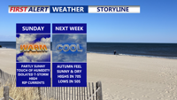
Delmarva can expect a warm, humid Sunday followed by a shift to cooler, drier air early in the week, bringing a taste of September weather just in time for the end of August.

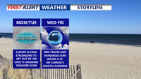
A stalled cold front south of Delmarva will bring sharply cooler, breezy conditions Monday, with highs only in the 70s under mostly cloudy skies with some showers possible. High pressure from the north will reinforce the cool pattern through midweek, while Hurricane Erin remains offshore but creates coastal hazards including high surf, rip currents, and possible flooding.


Delmarva will notice a big change in the weather starting Sunday night as a cold front sweeps across the region. The front is expected to pass from northwest to southeast late Sunday evening into the overnight hours, followed by a shift in winds from the southwest to the north and northeast. Low clouds are likely to form, with overnight lows dropping into the upper 60s to lower 70s by Monday morning.

Delmarva enters a stretch of mild, mostly dry weather beginning Wednesday night, thanks to high pressure settling to the north and northeast. Although a weak coastal low may trigger a few isolated showers later this week, most areas will remain dry with gradually warming temperatures. Humidity will increase early next week, bringing hot conditions and a slight chance of showers and storms.

A weakening disturbance will move through Sussex County late Friday into early Saturday, bringing gusty winds before a gradual warmup Sunday and Monday. Don’t forget to set your clocks ahead an hour Saturday night as daylight saving time begins.

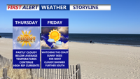
Delmarva faces a bitterly cold Friday despite clear skies, with gusty winds making temperatures feel like the teens and twenties. However, a warming trend is on the horizon, with highs climbing into the 40s over the weekend and even milder conditions next week. While the forecast turns unsettled, no major storm systems are expected.

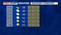
High pressure will dominate Delmarva today, bringing sunny skies and seasonable temperatures in the mid to upper 40s, though breezy conditions with gusts up to 25 mph are expected. A cold front arrives Tuesday night into Wednesday, followed by another system later in the week, bringing increased chances for precipitation Friday into Saturday.

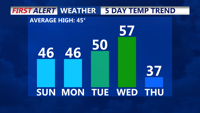
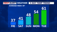
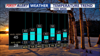
High pressure over the Southeast will bring seasonable temperatures and mostly dry conditions to Delmarva starting today. Temperatures will rise into the 50s by midweek as a January thaw sets in, but a stronger cold front late Wednesday will bring colder air by the week's end. Winds will gust up to 25 mph today, with highs in the mid to upper 40s. A brief dip in temperatures follows Thursday and Friday, with highs in the 20s and 30s before moderating slightly by Saturday.