


Delmarva enters a stretch of mild, mostly dry weather beginning Wednesday night, thanks to high pressure settling to the north and northeast. Although a weak coastal low may trigger a few isolated showers later this week, most areas will remain dry with gradually warming temperatures. Humidity will increase early next week, bringing hot conditions and a slight chance of showers and storms.
From
To

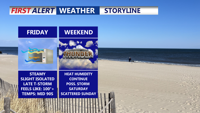
Delmarva will see dangerous heat and humidity Friday, with heat index values reaching up to 108 degrees and a Heat Advisory in effect. A cold front arriving late Friday will bring a chance of isolated storms, mainly north of Sussex County, before lingering near the region through Saturday and lifting north as a warm front Sunday. The weekend will be unsettled but not a total washout, with additional storm chances Sunday night. High pressure returns Monday before another frontal system arrives midweek.

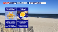
High pressure keeps Sussex County dry through Thursday, but dangerous heat and the chance of severe storms arrive Friday as a cold front approaches.

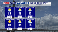
Thursday marks the final day of intense summer heat on Delmarva, for now. Temperatures will peak in the upper 80s to low 90s under partly cloudy skies, with oppressive heat indices ranging from 100 to 106 degrees.

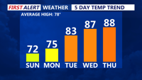
Sunday afternoon brings sunshine, cool temperatures, and breezy west winds across Delmarva. High pressure will dominate the region into midweek, leading to gradually warmer days and a potential return of summer heat by Thursday.

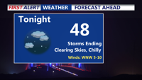
Storms have come to an end, clear and chilly night on tap as some areas away from the coast fall into the 40s. Bright, beautiful, breezy end to the weekend, summer-like next week as we make a run at our first 90 degree day of the year.

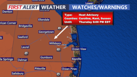
Sussex County can expect warmer temperatures and little relief overnight as the mid and upper-level ridge moves closer, maintaining the heat advisory.