


DELMARVA -- High pressure will keep Delmarva dry and sunny today, setting up a hot start to the weekend across the peninsula. As high pressure slides off the Mid-Atlantic coast later today and remains offshore into Saturday, temperatures will continue to climb.
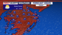
Today will be sunny, dry and hot, with highs reaching the low to mid 90s inland. Coastal communities and the beaches will be cooler, with highs mainly in the mid 80s. Dew points will stay in the 50s and 60s, so while it will be hot, humidity will not be overly oppressive. Late-day sea breezes are expected to develop near the coast.

Highs in the low to mid 90s inland, mid 80s at the beaches before a sea breeze.
An Air Quality Alert is in effect for Delaware today, with a Code Orange designation meaning air quality may be unhealthy for sensitive groups. The rip current risk is LOW for the Delaware Beaches, while Ocean City and points southward are under a MODERATE rip current risk.
Tonight will be mostly clear, with lows falling into the upper 60s.

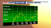
Humidity levels will rise Saturday into Sunday bringing a muggy conditions back to the area.
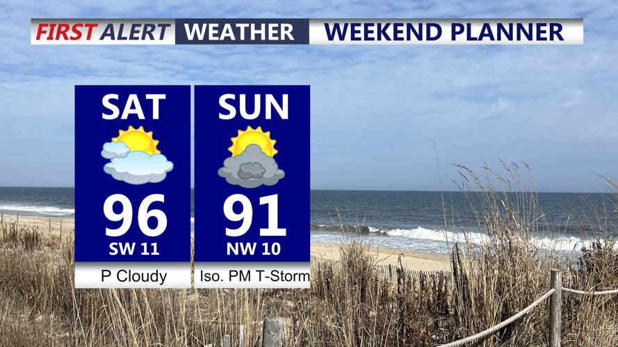
Saturday turns hotter and more humid across Delmarva. Highs will reach the mid 90s under partly cloudy skies. Saturday night will be very muggy, with lows in the upper 60s to low 70s. Showers and thunderstorms may develop Saturday night, though most of that activity is expected to remain north of Delmarva, potentially impacting New Castle County/I-95 Corridor with a gusty thunderstorm.

Hot and humid weekend on tap, a cold front will put an end to the heat late Sunday, could see an isolated gusty storm Sunday afternoon-evening.
A cold front will sweep through on Sunday, helping to break the heat. Highs will still reach the low 90s, and it will remain muggy. A few isolated gusty thunderstorms are possible, with the Storm Prediction Center placing the southern portion of Delmarva under a Marginal Risk for severe storms. The main threat with any stronger storms will be damaging winds.
Behind the front, high pressure builds in from the north early next week. That will bring briefly cooler temperatures, with highs in the 70s and 80s to start the week. Mainly dry weather is expected through much of next week, with temperatures gradually warming again as high pressure slides offshore and southerly flow returns. The main forecast concern for the second half of next week will be another stretch of above-normal heat, though a few low-end rain chances may also return.
