


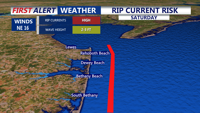
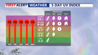
Delmarva will see sunny, dry, and warm conditions this weekend, with highs in the low 80s and calm nights. However, beachgoers should be aware of a continued dangerous rip current risk from Delaware Beaches through Ocean City and Chincoteague. The tranquil weather pattern will hold into early next week before heat and humidity make a return midweek.
From
To

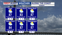
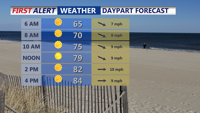
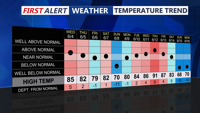
Sunday on Delmarva will bring bright, sunny skies, light winds and comfortable humidity as highs climb into the low to mid 80s. Overnight lows will drop into the upper 50s to low 60s under clear skies. While most of the week remains dry due to high pressure, beachgoers should remain cautious with a high risk of rip currents and waves reaching three to five fee


Tuesday’s forecast calls for oppressive heat and humidity across Delmarva, with a Code Orange air quality alert in effect for Sussex County.

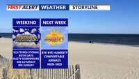
Delmarva will see scattered showers and storms this weekend, with the highest rain chances Saturday and a risk for stronger storms Sunday. Highs will reach the 80s and 90s before cooler, drier air moves in Sunday night. Early next week looks pleasant with sunshine and lower humidity, before warmer, stormier weather returns midweek.

Sussex County will see hot and humid conditions through Sunday, with scattered showers and thunderstorms mainly inland and occasional fog overnight.

Seasonably warm and increasingly humid conditions will build across Delmarva Sunday afternoon as high pressure shifts offshore. Highs will reach into the 80s to near 90, with an isolated thunderstorm possible by evening. By Monday and into midweek, a tropical air mass will set the stage for daily rounds of showers and thunderstorms. Some storms could produce heavy rainfall, localized flooding, and dangerous heat indices approaching 100 degrees inland.


High pressure offshore will usher in warmer and more humid air over Delmarva on Sunday, with highs climbing into the 80s to near 90 and muggy nights returning. While most areas should remain dry through Sunday, an isolated thunderstorm cannot be ruled out. By Monday and into the rest of the week, tropical moisture and unstable conditions will bring daily chances for showers and thunderstorms, some capable of heavy rainfall and localized flooding.

Showers and thunderstorms Thursday afternoon will be followed by clearing skies and seasonable temperatures into Friday morning.

Strong storms and a cold front Thursday evening will offer a brief break from the heat, but Sussex County will see rising temperatures and humidity again through the weekend into next week.

Sussex County faces a stretch of hot, humid weather with the threat of strong to severe thunderstorms Wednesday and Thursday ahead of a cooling trend by Friday.