


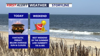
Delmarva will enjoy comfortable humidity, below-normal temperatures and mainly dry weather through the weekend before storm chances increase next week.
From
To

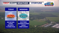
Hot and humid weather continues across Delmarva today before a cold front brings scattered storms tonight and unsettled conditions Saturday, followed by a drier Sunday.

Delmarva will see a mostly sunny and seasonably warm day today, with inland highs in the mid 80s and cooler conditions along the coast. A slow-moving cold front will bring increasing chances for showers and thunderstorms late Friday into Saturday before drier weather returns Sunday. Heat and humidity are expected to build again by the middle and latter part of next week.

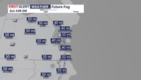
Fog and low clouds may linger late Saturday night before Sussex County sees a warmer, mainly dry Sunday, with rain chances increasing again late Sunday evening.


Showers and a possible thunderstorm may linger late Saturday before fog and low clouds develop overnight, followed by a milder and mainly dry Sunday in Sussex County.


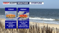
Delmarva stays locked under clouds today as a backdoor cold front keeps temperatures chilly, especially near the beaches. Fog and drizzle develop tonight, then milder air builds in this weekend with partial clearing Saturday afternoon, a chance for showers overnight Saturday into Sunday, and much warmer temperatures arriving early next week.

High pressure brings a calm, mostly sunny Saturday afternoon before a dry cold front ushers in gusty winds and seasonable warmth on Sunday.

A brief round of snow early Sunday gives way to bitter cold, gusty winds and wind chills in the single digits through Monday morning in Sussex County.

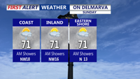
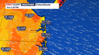
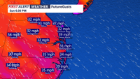
A stalled front and weak low pressure system will keep clouds and scattered showers over Delmarva Sunday, with highs only in the low to mid-70s. Conditions improve Sunday night as high pressure builds in, bringing dry and seasonable weather to start the week. A weak coastal low could bring more clouds midweek, while a warm, dry Thursday is followed by another cool and comfortable weekend.

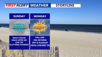
Clouds and scattered showers linger across Delmarva Sunday as a nearly stationary front and weak low pressure system pass through the region. Highs will remain cool, in the low 70s, before conditions clear late in the day. Dry weather and seasonable temperatures return Sunday night into Monday, with partly sunny skies and highs in the mid-70s. A weak coastal low could increase cloud cover Tuesday into Wednesday, followed by a stretch of dry, pleasant weather for the latter half of the week.