


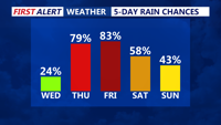
Severe storms, heavy rain and tropical humidity will persist through late Thursday evening as a slow-moving front wobbles across the region.
From
To

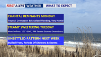
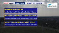
Beginning Sunday night, Delmarva will enter a period of high humidity and unsettled weather. The remnants of Tropical Storm Chantal will bring rounds of showers and thunderstorms Monday and Tuesday, with locally heavy rainfall and potential flash flooding. Severe storms possible Tuesday afternoon/evening. A stalled cold front will keep the region stormy through late week, while oppressive heat and humidity push heat index values to near 106 degrees.

Seasonably warm and increasingly humid conditions will build across Delmarva Sunday afternoon as high pressure shifts offshore. Highs will reach into the 80s to near 90, with an isolated thunderstorm possible by evening. By Monday and into midweek, a tropical air mass will set the stage for daily rounds of showers and thunderstorms. Some storms could produce heavy rainfall, localized flooding, and dangerous heat indices approaching 100 degrees inland.


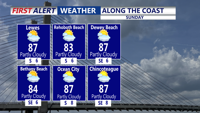
High pressure offshore will usher in warmer and more humid air over Delmarva on Sunday, with highs climbing into the 80s to near 90 and muggy nights returning. While most areas should remain dry through Sunday, an isolated thunderstorm cannot be ruled out. By Monday and into the rest of the week, tropical moisture and unstable conditions will bring daily chances for showers and thunderstorms, some capable of heavy rainfall and localized flooding.

Pleasant weather will continue Saturday night across Delmarva, with partly cloudy skies and lows in the 60s. As high pressure shifts offshore, temperatures and humidity will climb Sunday into Monday. By early next week, a tropical and unsettled pattern will bring daily chances of showers and thunderstorms, heavy rainfall, and heat indices over 100 degrees.

High pressure will maintain calm and seasonable weather across Delmarva through the holiday weekend. Temperatures will climb into the upper 80s and low 90s by Sunday, with humidity gradually increasing. By early next week, a tropical, unsettled pattern is expected to develop, bringing daily chances for showers and thunderstorms along with oppressive heat and potential localized flooding.

Delmarva residents can expect a mix of misty mornings, low clouds, and scattered showers starting Sunday. Highs will range from the mid to upper 70s, with some inland areas possibly reaching 80 degrees. The weather pattern will remain unsettled due to a stalled front and the remnants of tropical moisture, leading to continued cloudy and damp conditions into midweek. Occasional rain showers are likely, especially Monday night into Tuesday, with the potential for isolated downpours. A cold front will move through by Wednesday, bringing slightly cooler but generally dry conditions for the latter part of the week.

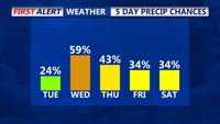
Cloudy conditions and scattered showers will dominate the weather pattern across Delmarva on Tuesday, with temperatures remaining mild. Rain chances will increase late Tuesday into Wednesday as tropical moisture associated with the remnants of Potential Tropical Cyclone 8 and a coastal low move into the region. Unsettled weather is expected to continue into Thursday with the possibility of heavy rain, although flood risk remains low due to recent dry conditions. Temperatures will stay in the 70s during the day and 60s at night throughout the week.


A slight chance of scattered showers will develop across Delmarva tonight, with increasing precipitation chances moving northward through Tuesday. Low temperatures tonight will be mild, staying in the upper 60s. On Tuesday, the cloudy and mild conditions will persist, with highs reaching the mid to upper 70s. Northeast to east winds around 10 mph will continue. As we move into Wednesday, the remnants of Potential Tropical Cyclone 8 and a secondary coastal low could bring periods of heavy rain, although the track of these systems remains uncertain.


The week starts quiet on Delmarva, but an approaching low-pressure system could bring significant rain and tropical-like downpours by Tuesday afternoon and evening.