


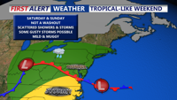
A damp and stormy weekend as unsettled weather takes hold. A weak cold front and associated low pressure system will bring widespread showers and possible thunderstorms Saturday, followed by another round Sunday afternoon with the arrival of a warm front. The Storm Prediction Center places Delmarva under a Marginal Risk for severe weather Saturday, with damaging winds as the main concern. Intermittent clearing arrives Monday before a fresh round of storms hits Tuesday.
From
To

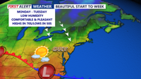
Sunday afternoon brings spectacular weather to Delmarva, with sunshine, mild temperatures, and breezy conditions. A pair of cold fronts will refresh the region with cooler, drier air through Monday and Tuesday, under the influence of high pressure. The tranquil start to the week will give way to a more unsettled stretch midweek, with rain chances increasing sharply by Wednesday and Thursday as a dynamic storm system approaches. Temperatures will trend cooler heading into the weekend.

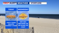
Patchy fog gives way to partly sunny skies and warm temperatures. A mix of isolated showers and storms will punctuate the rest of the week as multiple upper-level systems move through the region, bringing cooler temperatures and increased rain chances into the weekend.


Rain and downpours return to Delmarva Sunday with a stretch of unsettled weather lasting into Tuesday as multiple waves of energy track through the region. While conditions briefly dry out by midweek, another cold front and upper-level system will bring more showers and cooler temperatures before the weekend.

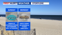
Scattered showers and storms with highs in the low to mid 70s Sunday. A mild, humid weekend transitions into a wet and cooler start to the workweek across Delmarva, with periods of heavy rain and thunderstorms expected through Tuesday. A cooler, more stable pattern begins to emerge by the end of the week.

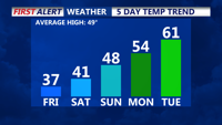
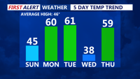
We can continue to look forward to a dry, pleasant weekend beginning Saturday night with mild temperatures and partly cloudy skies. Sunday promises seasonable, mostly sunny conditions, while a gradual warming trend kicks in early next week with highs climbing into the 50s and 60s. Later in the week, a stronger cold front brings our best chance for rain on Thursday before a cooler Canadian air mass returns Friday.

Delmarva faces a bitterly cold Friday despite clear skies, with gusty winds making temperatures feel like the teens and twenties. However, a warming trend is on the horizon, with highs climbing into the 40s over the weekend and even milder conditions next week. While the forecast turns unsettled, no major storm systems are expected.

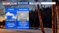
Delmarva will see a dry but breezy Super Bowl Sunday, with highs reaching the mid to upper 40s. A period of calmer weather follows Monday before a series of storm systems bring accumulating snow and mixed precipitation to the region midweek. High pressure will return to close out the week.

Delmarva begins the first full week of February with mild temperatures, but a cold front moving in Monday night will set the stage for a shift in conditions. High pressure keeps the region dry through Tuesday, but a midweek system could bring a mix of rain, snow, and sleet by Wednesday afternoon. Another system arrives by the weekend, keeping unsettled conditions in the forecast.

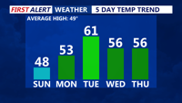
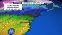
Seasonable conditions today, with highs in the mid-40s and increasing clouds as a warm front approaches. Monday brings much milder temperatures, with the upper 50s to low 60s. A cold front moves through late Monday night, keeping Tuesday’s highs similar to Monday but occurring earlier in the day. By midweek, a more active pattern develops, with a low-pressure system bringing widespread precipitation Wednesday through Thursday night.