





Delmarva will remain hot and humid through the middle of the week with daily chances for showers and thunderstorms. Some storms could produce strong winds, heavy downpours and localized flash flooding, while minor tidal flooding is also possible along Delaware’s Atlantic coast and Delaware Bay during evening high tides. A cold front should bring cooler, much drier and more comfortable weather by Friday and Saturday.
From
To


Periods of heavy rain and thunderstorms could cause localized flash flooding across Delmarva today before a brief break Tuesday.


Scattered storms may bring damaging winds and flooding before drier air arrives.


Severe storms and flooding remain possible through Wednesday night.


Damaging winds, torrential rain, isolated tornadoes and flash flooding are possible across Delmarva today and Wednesday.

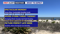
Delmarva will enjoy one more pleasant and mostly sunny day Monday before humidity, showers and strong thunderstorms return Tuesday.

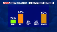
Sussex County could see scattered showers and isolated storms from early Wednesday into Thursday morning as a warm front lifts through the region.


Showers and thunderstorms may move into Sussex County early Wednesday, with additional storm chances through the day before humid conditions continue into early Thursday.

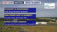
Delmarva will enjoy a beautiful and seasonable day today, with highs in the low 80s inland and low 70s along the coast. Humidity begins to return tonight, setting the stage for scattered showers and storms Wednesday and Thursday. Dangerous heat is likely late this week, especially Thursday and Friday, before a cold front brings some relief into the weekend.

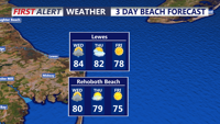
Showers and storms are expected early Wednesday through Wednesday evening before quieter weather returns by Thursday morning.