


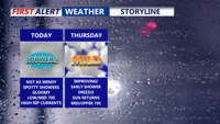
A weakening coastal storm will keep Delmarva cloudy and damp through Wednesday, but conditions are set to improve Thursday as skies clear and temperatures rise. High pressure will bring sunny, cooler weather through the weekend before another warm-up early next week.
From
To

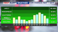
A stalled front lingering over the Delmarva Peninsula will keep the region humid through the weekend, with occasional showers and storms. Although conditions will ease somewhat compared to midweek, isolated flash flooding and strong wind gusts remain possible. A stronger cold front will arrive early next week, bringing more widespread storms and a gradual drying trend.

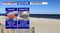
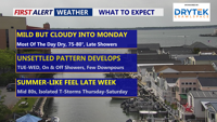
A weak cold front moving into Delmarva Saturday night will stall and keep unsettled conditions through early next week. After a hot and humid Sunday, a warm front lifting north Monday will bring scattered storms and sweltering heat indices above 100 degrees inland. By Tuesday, a stronger cold front could trigger severe thunderstorms with damaging winds. Drier, more comfortable weather gradually arrives mid to late week, just in time for the Fourth of July weekend.


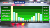
A surge of heat and humidity as a warm front lifts north, pushing temperatures to around 90 degrees with heat indices topping 100 in spots. Isolated storms could develop in the afternoon and evening, with a cold front stalling nearby Sunday and briefly easing humidity. Another warm front Monday will keep conditions warm and unsettled before a stronger cold front crosses the region Tuesday, bringing a renewed risk of thunderstorms. High pressure will build midweek, delivering drier and more comfortable weather.

A developing coastal storm is bringing periods of rain and gusty winds to Delmarva beginning Wednesday afternoon, with temperatures stuck in the 50s. The unsettled pattern continues into Thursday before tapering into scattered showers Friday. A gradual clearing trend and slightly warmer weather is expected over the weekend, though cooler-than-average temperatures persist.

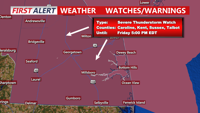
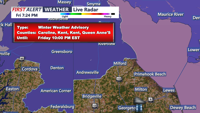
DELMARVA -- Stay Weather Aware — Dangerous storms are possible

Mother's Day brought blue skies and temperatures in the low 80s across the Delmarva Peninsula, but the region will soon trade sun for showers as a series of low-pressure systems and cold fronts approach. Rain chances increase starting Monday night, with several rounds of wet weather expected through Saturday.

Bitter cold conditions will grip Sussex County through Saturday night and Sunday, with lows in the teens and highs struggling to reach the mid-30s. Forecasters are monitoring a potential snowstorm expected to impact the area late Sunday night into Monday.

Sussex County saw light snow Friday evening, with totals generally around an inch or less. As temperatures drop into the 20s overnight, strong winds will make for biting wind chills into early Saturday.

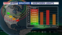
A strong solar storm is giving Delmarva residents a rare opportunity to catch a glimpse of the Northern Lights tonight, with clear skies and mild temperatures expected. A quiet weather pattern will follow through the weekend, with high pressure and dry conditions. Temperatures will warm slightly on Saturday, while a dry cold front brings cooler, breezy conditions for early next week.