


Windy day on the way, with a threat for severe weather later today.
From
To

Increasing wind into Monday with a growing threat for severe weather.

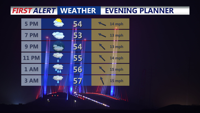
For the rest of Saturday afternoon and evening skies remain mostly cloudy skies with diminishing winds and temperatures in the 50s.


Today across Delmarva, a powerful cold front is bringing a stunning turnaround in the weather, with temperatures crashing 40 to 50 degrees from yesterday’s record-breaking warmth. Rain showers will mix with and briefly change to wet snow late this afternoon for a few hours, with only a light coating possible on grassy and elevated surfaces while roads stay mostly wet. Gusty winds of 30 to 40 mph will add to the chill, sending wind chills into the upper 20s and low 30s by late day.

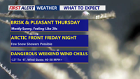
Light to moderate rain moves across Delmarva this afternoon into the evening with temperatures in the mid 40s, then exits later tonight. Friday turns bright and milder near 50, with Saturday the pick of the weekend near 60 and sunshine. A dry front slips through Sunday, and we’re monitoring the potential for accumulating snow Monday night into Tuesday morning, though confidence remains low for now.

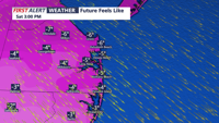
From early Saturday morning into Sunday morning, an arctic blast will bring potentially damaging wind gusts, life-threatening wind chills, and dangerous marine icing from Sussex County, Delaware, to Ocean City, Maryland

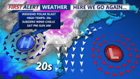
A cold stretch that turns downright harsh this weekend, with the biggest headline being dangerous wind chills and strong winds, not snow.


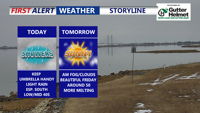
Sussex County is expected to stay mostly calm through Friday evening, with light snow developing late and a much more dangerous wind-and-cold outbreak slated for the weekend.

Delmarva stays sunny but cold today, then turns cloudier Friday ahead of a clipper and an arctic front. Snow looks minimal (if any, just a dusting), but a sharp temperature crash and powerful winds arrive Saturday—bringing dangerous wind chills into the single digits and potentially below zero.

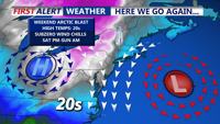
Colder-than-normal temperatures have settled across Delmarva, with highs ranging from the mid-30s to low 40s. The chill deepens by Thursday and into the weekend, as an arctic cold front approaches. While light snow is possible Friday, more impactful snow squalls and dangerously cold wind chills are expected Friday night into Saturday. Gusty winds behind the front may reach 50 mph, especially near the coast.