


DELMARVA - An amplified wave approaching Delmarva will result in scattered to numerous showers and thunderstorms this evening. As an upper-level trough deepens to our west, the overall upper-level synoptic setup will become more favorable for storm development. This system will increase the southwesterly flow aloft, drawing more moisture into the region. Precipitable Water values (PWATs) are forecasted to rise to 2-2.5 inches across much of the area, enhancing the potential for heavy downpours and localized flooding. Model soundings indicate that storm motions should prevent storms from remaining stationary over one area for too long, reducing the risk of prolonged heavy rainfall. However, some convective models suggest that the thunderstorms may organize into clusters or lines, increasing the risk of damaging wind gusts.
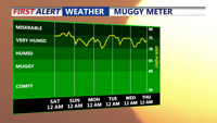
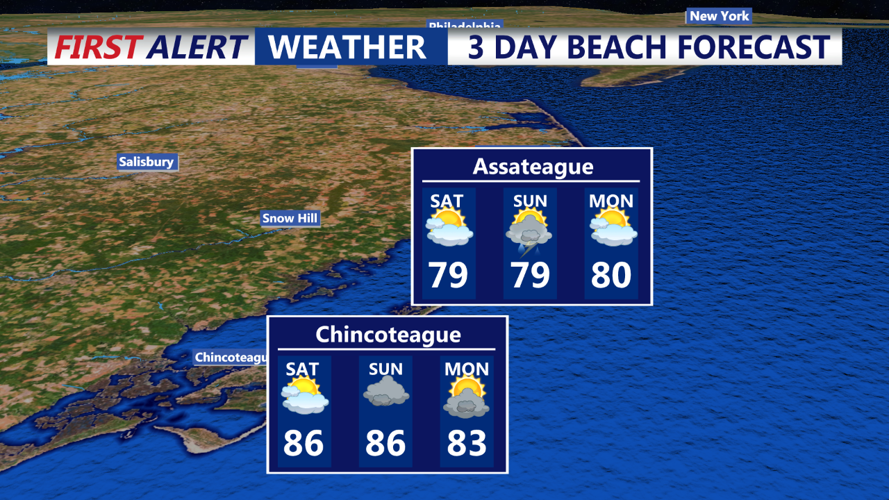
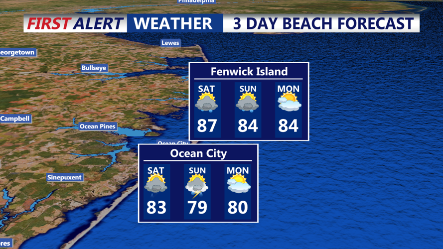
Saturday Morning: As the upper-level trough shifts closer to the Great Lakes and Ohio Valley, Delmarva will experience a continuation of unsettled weather. The air mass will remain very moist, contributing to ongoing showers and thunderstorms. Morning temperatures are expected to quickly rise into the upper 80s to low 90s, accompanied by high humidity. There is a possibility of a heat advisory being issued, depending on how high the temperatures climb. Ensemble guidance indicates two possible scenarios: one with a weaker trough and cooler temperatures due to less intense southerly flow, and another with a sharper trough and stronger southerly winds, which could push temperatures above 90 degrees.
Saturday Afternoon: The trough will continue to influence Delmarva's weather, maintaining the likelihood of showers and thunderstorms throughout the afternoon. The high humidity and temperatures in the upper 80s to low 90s will persist, with the potential for heat advisories if temperatures reach the higher end of forecasts. The risk of localized flooding from heavy downpours remains, and there is still a threat of damaging wind gusts from any stronger storms that develop.
Stay tuned to your local weather updates for the latest information and be prepared for rapidly changing weather conditions throughout the weekend.