




DELMARVA - A dry cold front will move across early Friday morning, bringing a noticeable increase in northwest winds before cooler temperatures settle across neighboring coastal communities heading into Halloween.
Friday morning will begin on a relatively mild note, with temperatures generally in the upper 40s to lower 50s. Skies will be partly cloudy as the cold front crosses the region, but no significant rainfall is expected.
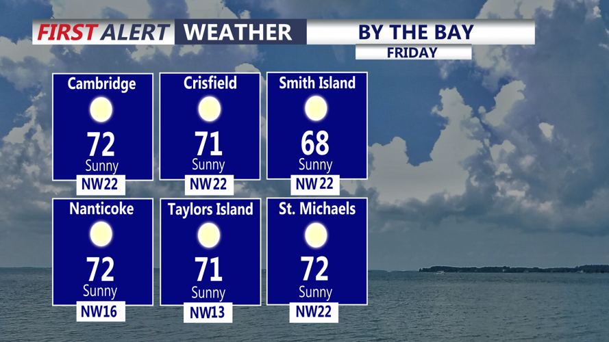
Behind the front, winds will shift from the southwest to the northwest and strengthen throughout the morning. Sustained winds of 10 to 15 mph are expected, with occasional gusts reaching 25 mph during the afternoon.
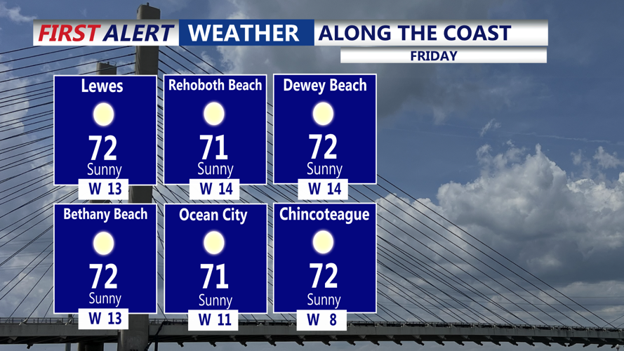
Communities including Georgetown, Seaford, Laurel, Millsboro, Milford, and Salisbury will experience breezy conditions as cooler, drier air moves into the region. Along the beaches, including Lewes, Rehoboth Beach, Dewey Beach, Bethany Beach, Fenwick Island, and Ocean City, gusty northwest winds will be particularly noticeable in exposed locations.
Despite the passage of the cold front, Friday afternoon temperatures will remain relatively comfortable, reaching the upper 60s to near 70 degrees in many areas. Increasing sunshine and dry conditions will make for generally pleasant weather, although the gusty winds may create a cooler feel at times.
By Friday evening, cooler air will begin spreading as high pressure builds toward the region. Winds will gradually diminish overnight, allowing temperatures to fall steadily under partly cloudy to mostly clear skies.
By early Saturday morning, Halloween, temperatures are expected to drop into the middle and upper 30s across inland communities, including Georgetown, Seaford, Laurel, and Salisbury. Coastal locations from Lewes to Fenwick Island will generally remain somewhat milder, with lows in the lower to middle 40s.
Although temperatures will approach the freezing mark in a few colder inland locations, widespread frost is not currently expected across areas where the growing season remains active.
Residents heading outdoors early Saturday should prepare for a chilly start, particularly away from the immediate coastline.
Halloween afternoon will feature cooler but dry conditions. Temperatures are expected to reach only the upper 50s to lower 60s beneath partly cloudy skies. The forecast remains favorable for Halloween celebrations, neighborhood activities and evening trick-or-treating.
Temperatures Saturday evening will fall through the 50s and eventually into the 40s, making jackets or additional layers a good idea for children and families spending time outdoors.
Sunday will bring partly to mostly cloudy skies, with temperatures recovering slightly into the lower and middle 60s. Dry conditions are expected to continue through the beginning of next week as high pressure remains the dominant weather influence.
A potential storm system early next week now appears likely to weaken and largely miss Delmarva. Although cloud cover may increase, the likelihood of widespread rainfall remains low through at least Tuesday. A few showers remain possible by the middle of next week, with a potentially more significant rain system approaching late next week.
For boaters and coastal interests, northwest winds will strengthen Friday afternoon and continue into Friday night. Winds over the Atlantic coastal waters may reach 17 to 23 mph, with gusts approaching 29 mph and potentially 35 mph farther offshore.
A Small Craft Advisory is in effect for portions of the northern New Jersey coastal waters, with the possibility that marine advisories could eventually expand farther south if stronger gusts develop closer to the coast.
Conditions are expected to improve over the weekend, with no significant marine hazards anticipated Saturday through early next week.
Overall, a mild and breezy Friday to a much cooler Halloween morning, followed by a dry and seasonably cool weekend across southern Delaware and the nearby Maryland beaches.
