


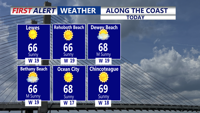


DELMARVA -- A pleasant stretch of fall weather following the passage of a cold front early today. Skies will stay mostly sunny through the afternoon, with seasonable highs reaching the mid to upper 60s.

Sunny breezy afternoon along the coast with highs in the mid to upper 60s.
Winds from the west will remain gusty, reaching 25 to 30 mph before easing to 5 to 10 mph overnight.

Winds will gust out of the west 25-30 mph, it will be breezy the next few afternoons.
Cooler conditions are on the way tonight, with lows dipping into the low to mid-40s, and even some upper 30s possible in inland areas.

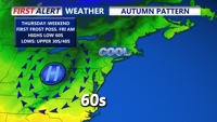
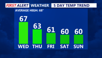
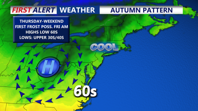
Temperatures will be running below average from Thursday through the weekend.
Another front is expected to move through on Thursday. Daytime clouds will develop, and temperatures will run a few degrees below normal for late October, with highs in the upper 50s to low 60s. Gusty winds up to 30 mph may accompany the front. As skies clear Thursday night and into Friday, light winds and clear skies will allow for effective radiational cooling, leading to overnight lows in the mid to upper 30s inland and low 40s along the coast. Some frost may develop in colder inland spots.
Looking ahead to the weekend, high pressure will dominate, delivering tranquil and seasonable conditions. Expect mostly clear skies and highs in the upper 50s to low 60s. With the high nearly overhead Saturday night, another round of patchy frost is possible as temperatures dip into the 30s. The calm pattern should hold into early next week before another system approaches by midweek, potentially bringing rain chances back to the forecast by Tuesday night.