




DELMARVA - High pressure will continue to dominate the weather across Sussex County late Sunday evening through Monday evening, bringing generally quiet conditions, chilly overnight temperatures and a gradual warming trend to southern Delaware and neighboring coastal communities.
Late Sunday evening will feature partly cloudy skies and light winds as high pressure remains positioned near the Mid-Atlantic region. Temperatures will steadily fall overnight, reaching the upper 30s to lower 40s across much of Sussex County by early Monday morning.
Inland communities including Georgetown, Seaford, Laurel and Millsboro could experience some of the coldest temperatures, with a few sheltered locations potentially dipping into the middle 30s. Patchy frost cannot be completely ruled out in colder inland areas, although the greater potential for frost will remain across interior Pennsylvania and New Jersey.
Along the Delaware beaches, including Lewes, Rehoboth Beach, Dewey Beach, Bethany Beach and Fenwick Island, overnight temperatures will generally remain in the lower to middle 40s, reducing the likelihood of frost near the immediate coastline.
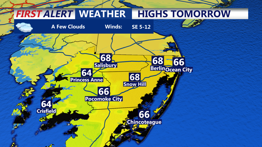
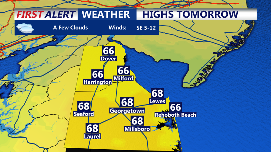
Monday will bring another pleasant November day across Sussex County, with partly sunny skies, light southwest winds and temperatures climbing into the middle to upper 60s. Some inland communities could approach 70 degrees during the afternoon as the warming trend continues.
Winds will remain relatively light throughout the day, generally around 5 mph or less, making conditions favorable for outdoor activities, travel and recreation across southern Delaware.
By Monday evening, skies will remain partly cloudy as temperatures gradually fall through the 50s. Unlike Sunday night, overnight temperatures heading into Tuesday are expected to remain milder, with little concern for additional frost or freezing conditions.
The stretch of tranquil weather will continue through Tuesday and Wednesday as high pressure remains the dominant influence across Delmarva.
Afternoon temperatures are expected to climb into the upper 60s and lower 70s Tuesday, followed by even warmer conditions Wednesday, when highs could reach the lower to middle 70s. These readings will be above normal for early November.
Despite occasional periods of high cloud cover, dry conditions should continue through Wednesday afternoon.
The weather pattern is expected to change during the second half of the week as a developing storm system approaches the Mid-Atlantic.
An upper-level disturbance moving from the central United States toward the Great Lakes and eastern Canada will gradually weaken the high-pressure system that has kept Delmarva dry.
Rain chances could return as early as Wednesday night, although Thursday and Friday currently appear to offer the greatest opportunity for widespread rainfall.
The probability of precipitation is estimated at 50% to 60% across much of the region during that period.
At this time, the developing system appears more likely to produce periods of beneficial rainfall rather than widespread severe weather. Atmospheric instability looks limited, reducing the potential for strong thunderstorms.
Some uncertainty remains regarding the exact timing, coverage and intensity of rainfall. The unsettled pattern could linger into Saturday before cooler and drier air begins returning Sunday.
For coastal communities, conditions on the Delaware Bay and nearby Atlantic waters will remain favorable through Monday. Winds will be light overnight before becoming southwest around 10 to 12 mph Monday. Seas are expected to range from 1 to 3 feet, with no significant marine hazards anticipated.
Marine conditions could deteriorate Thursday into Friday as southeast winds strengthen to 12 to 17 mph, with gusts approaching 29 mph. Seas could build to 3 to 5 feet, potentially creating conditions hazardous to smaller vessels.
Periods of rain may also reduce visibility over coastal waters late in the week.
Overall, Sussex County can expect a comfortable start to the first full week of November, with chilly mornings giving way to increasingly mild afternoons before a potentially wetter weather pattern develops toward the end of the week.
