


DELMARVA - Clear skies and cool, dry conditions are expected across Sussex County from late Thursday evening through Friday evening as high pressure continues to build into the region.
North-northwest winds will ease after sunset Thursday but remain around 10 mph overnight due to a tight pressure gradient. The steady breeze will limit significant radiational cooling, though sheltered inland areas could cool more efficiently. Overnight lows will dip into the mid-30s to low 40s, but frost is not anticipated, and no advisories have been issued.
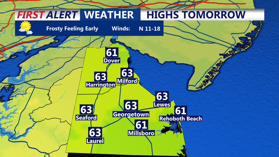
On Friday, the center of high pressure will move into the Ohio Valley and Appalachian Mountains, leading to calmer conditions. Winds will remain near 10 mph with occasional gusts up to 20 mph. Skies will stay mostly sunny and dry, with afternoon highs in the low to mid-60s. Dew points will remain in the low 30s, keeping humidity in the low to mid-30% range. With lighter winds, the risk of fire weather will stay low.
Friday night will bring another clear and calm evening as high pressure slides closer to the East Coast. Winds will become light, and temperatures could dip slightly cooler than forecast. If they do, some patchy frost could develop in colder spots. Rising dew points and increasing late-night cloud cover may limit significant cooling.
Clouds will gradually increase Saturday, but dry weather is expected to continue.