


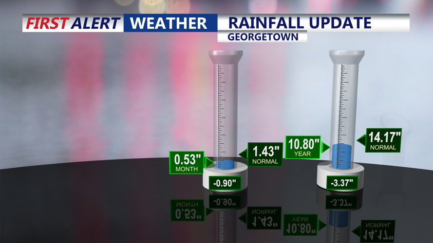


DELMARVA - Rain has moved out of southern Delaware and coastal Maryland, but clouds and cool air will linger into late Thursday evening as a large upper-level low remains positioned near the eastern Great Lakes.
Northwest winds may stay a bit breezy early Thursday evening behind a cold front, but winds are expected to ease overnight. Skies should partially clear late Thursday night, allowing for a calm and chilly start to Friday. Overnight lows will fall mainly into the 40s, with readings near 50 degrees closer to the coast, including Ocean City.
Friday will bring improving weather as the upper-level low begins to pull away and high pressure gradually builds into the region. Sussex County and Ocean City can expect a mix of sunshine and clouds through the day, with highs rebounding into the upper 60s to lower 70s. Coastal areas may remain slightly cooler with a light onshore influence.
By Friday evening, conditions should remain dry and comfortable, setting up a warmer pattern for the weekend. Temperatures are expected to climb above normal Saturday through early next week, with inland areas potentially reaching the 80s and eventually the 90s. Coastal communities, including Ocean City and the Delaware beaches, are expected to stay cooler than inland spots.
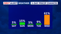
The stretch should remain mostly dry through Tuesday, though an isolated shower or thunderstorm cannot be ruled out Sunday. A cold front may approach by the middle of next week, bringing the next better chance for showers and storms.
