




DELMARVA - A strengthening coastal storm will gradually pull away from the Mid-Atlantic late Thursday evening through late Friday evening, bringing lingering showers, areas of fog and increasingly strong northwest winds as a much colder air mass settles over southern Delaware.
The threat of tornadoes has ended, and the Tornado Watch issued earlier Thursday has been canceled. However, unsettled weather will continue as low pressure moves offshore and tracks northeastward toward New England.
Scattered showers will remain possible Thursday night across Sussex County, including Georgetown, Seaford, Laurel and Millsboro, as well as coastal communities from Lewes and Rehoboth Beach south through Bethany Beach and Fenwick Island.
Low clouds and patchy fog are expected to develop overnight, particularly in locations that received rainfall earlier Thursday. Visibility could become locally reduced, creating potentially hazardous driving conditions along Route 1, Route 113 and other major roadways.
Overnight temperatures will gradually fall into the upper 30s and lower 40s as northwest winds begin drawing colder air into the region.
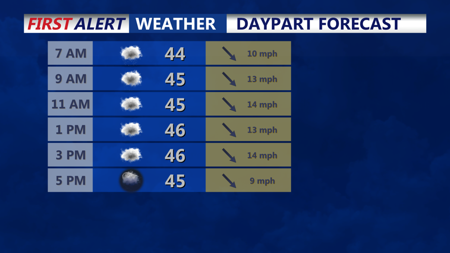
Friday will bring mostly cloudy skies, occasional light rain and a noticeable increase in wind speeds as the coastal storm continues strengthening offshore.
Rainfall amounts across southern Delmarva are expected to remain limited, generally totaling less than one-tenth of an inch from the remaining precipitation associated with the system.
However, persistent low clouds, occasional showers and areas of fog could keep conditions damp and dreary throughout much of Friday.
Northwest winds will increase to 10 to 20 mph, with gusts reaching 25 to 30 mph, particularly along Delaware's Atlantic beaches and other exposed coastal locations.
Temperatures will struggle to climb out of the 40s Friday afternoon across much of Sussex County, marking the beginning of an extended stretch of below-normal temperatures.
The combination of chilly air and gusty northwest winds will make it feel considerably colder, especially along the beaches from Lewes and Rehoboth Beach south through Dewey Beach, Bethany Beach and Fenwick Island.
Meanwhile, hazardous marine conditions will continue along Delaware's Atlantic coastal waters and Delaware Bay.
A Small Craft Advisory remains in effect for all area waters, with increasing winds and building seas making conditions dangerous for smaller vessels. Occasional gale-force wind gusts will also be possible Friday as the offshore storm intensifies.
Boaters and commercial fishing operators should anticipate hazardous conditions continuing through much of the weekend.
By Friday evening, scattered showers should gradually diminish as drier air begins spreading into southern Delaware. However, northwest winds will remain gusty, and temperatures will continue falling as the colder air mass becomes firmly established.
The coldest weather is expected Friday night into Saturday morning, when temperatures across inland Sussex County could fall into the upper 20s and lower 30s. Coastal communities may remain slightly milder, although freezing temperatures will still be possible in some locations.
The developing cold spell could produce the first widespread freeze of the season across portions of Delmarva. Frost or freeze advisories and warnings may be necessary where the growing season remains active.
Saturday will remain cold and blustery, with afternoon temperatures generally staying in the 40s and northwest wind gusts approaching 30 mph. Gusty conditions will continue Sunday, although winds should gradually weaken.
Despite the storm's strength and the arrival of colder temperatures, snow is not expected across Sussex County. Any accumulating snowfall should remain confined to higher elevations of northeastern Pennsylvania, particularly the Pocono Plateau.
Temperatures will begin a slow recovery Sunday into early next week, but afternoon highs will generally remain in the upper 40s to lower 50s, keeping conditions below seasonal averages.
For residents across Sussex County and Delaware's beach communities, Friday will mark a sharp transition from relatively mild November weather to a colder, windier pattern that will dominate the weekend.
