


DELMARVA - Sussex County residents should prepare for unsettled weather starting late Tuesday and lasting into Thursday night as a cold front works into the region.
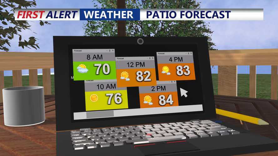
Late Tuesday into this evening, temperatures will remain above seasonal norms, mostly in the upper 70s to low 80s, with the warmest conditions away from the coast. A shortwave energy with the approaching front may trigger showers and the chance of a few thunderstorms late Tuesday afternoon and evening. There is a marginal risk for severe thunderstorms near and northwest of the I-95 corridor, mainly stemming from damaging straight-line wind gusts. As the sun sets and the heating diminishes, storm chances should taper off after midnight. Lows will drop into the low to mid-60s (upper 50s in higher terrain).
On Wednesday, the cold front will linger across northern parts of Sussex County. The chance for showers and thunderstorms will be limited (around 20-30%), especially northward, with afternoon highs reduced a bit but still above normal.
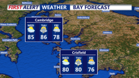
Wednesday night into Thursday night marks the period of greatest rainfall chances. The front will sag south across the central and southern zones, raising rain and storm chances (40-80%), particularly later Wednesday and into Thursday. Thursday looks increasingly wet during the afternoon into evening as another cold front approaches from the west. Afternoon highs will be more seasonal—mid 70s to around 80 °F—though southern elevated areas may see cooler values. Humidity will be high, contributing to muggy conditions. Overnight lows will mostly stay in the 60s.
Precipitation totals from Wednesday through early Friday morning are expected to run about 1 to 2 inches, with the possibility of localized heavier amounts.
Beyond Thursday night, the front is expected to pass through and then stall to the south. Friday into the weekend will bring lingering chances of showers and thunderstorms, though the atmosphere may gradually stabilize. Temperatures during that period will trend toward more normal values. Broader high pressure is predicted to build in from the west by Sunday into early next week, though tropical activity over the western Atlantic could influence conditions depending on how systems interact.