






DELMARVA - A cold front moving through Sussex County late Sunday will usher in cooler weather, but rain chances will linger into Monday as the boundary stalls south of the region.
Periods of rain are possible Sunday evening and overnight, with low clouds and patchy fog developing behind the front. The rainfall is expected to be mainly steady rather than stormy, with the risk of flash flooding remaining low.
Monday will stay cloudy, cool and damp, with additional periods of rain possible as the stalled frontal boundary remains nearby. Temperatures are expected to struggle through the 60s, running below normal for late September.
Northeast winds will increase during the day Monday, especially near the coast. Winds along the Delaware beaches are expected to reach 15 to 20 mph, contributing to rougher surf conditions.
A moderate risk of dangerous rip currents is expected Monday along the Delaware beaches, with breaking waves of about 2 to 4 feet. Boaters will also face deteriorating conditions as northeast winds strengthen and Atlantic seas build.
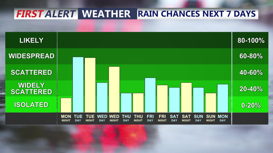
Rain chances are expected to remain in the forecast into Tuesday, when the frontal boundary may attempt to lift north again. Tuesday currently appears to have the greatest chance for rain across much of Delmarva before precipitation chances begin to decrease later in the week.
