




DELMARVA - A cooler and breezy weather pattern will settle across Sussex County Saturday as a departing storm system moves farther into the Atlantic, bringing improving conditions following Friday's widespread rainfall.
Saturday morning will begin with a mixture of sunshine and clouds as drier air continues moving into southern Delaware. Temperatures will start in the lower to middle 40s across inland communities, including Georgetown, Seaford, Laurel and Millsboro, while locations closer to the Atlantic coast may remain slightly milder.
A brisk west to west-northwest wind will develop during the morning as low pressure strengthens northeast of the region and high pressure builds across the central United States.
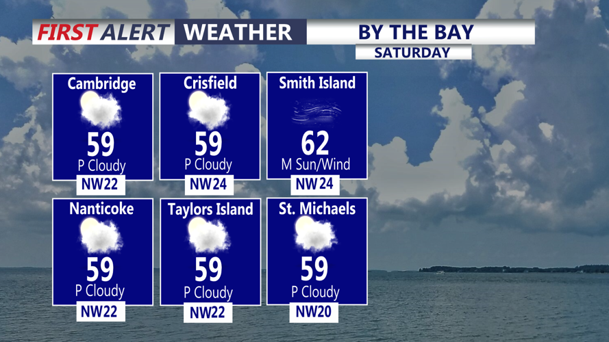
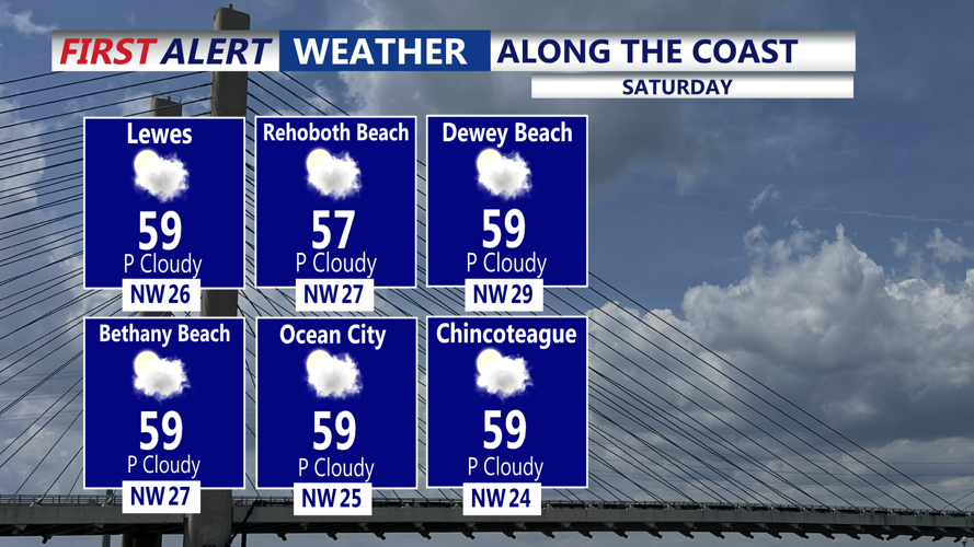
Winds will generally blow between 10 and 15 mph, with occasional gusts reaching 25 mph, especially in open areas and along the Delaware beaches from Prime Hook and Lewes south through Rehoboth Beach, Bethany Beach and Fenwick Island.
Although sunshine will occasionally break through the clouds, temperatures will remain noticeably cooler than the unusually warm conditions experienced earlier in the week. Afternoon highs will generally reach the upper 50s to around 60 degrees across Sussex County.
The gusty winds will make it feel even cooler, particularly along the beaches, boardwalks and other exposed coastal locations.
Despite the breezy conditions, Saturday should remain dry across southern Delaware. The upper-level disturbance responsible for the unsettled weather will move across the region, but the greatest chance for any lingering showers will remain well north of Sussex County.
Saturday afternoon will feature a mixture of sunshine and passing clouds, with dry conditions continuing into the evening.
Marine conditions will become increasingly unsettled as northwest winds strengthen over the Delaware Bay and Atlantic coastal waters. Wind gusts could approach 30 to 35 mph offshore, with seas building to 4 to 6 feet. Small Craft Advisories may be necessary for portions of the coastal waters.
Boaters and those planning offshore activities should monitor changing marine conditions, particularly Saturday afternoon and Saturday night.
As Saturday evening approaches, skies will gradually become mostly clear to partly cloudy. Winds will slowly diminish as the pressure difference between the departing low and approaching high pressure begins to weaken.
Temperatures will fall steadily through the evening, dropping into the 40s shortly after sunset across much of Sussex County.
By late Saturday night and early Sunday morning, temperatures are expected to reach the upper 30s to middle 40s. Inland communities such as Seaford, Laurel, Georgetown and Bridgeville could experience the coldest readings, while coastal towns including Lewes, Rehoboth Beach, Bethany Beach and Fenwick Island should remain several degrees milder.
Sunday morning will begin on a chilly but generally quiet note, with mostly clear skies, light winds and temperatures gradually recovering after sunrise.
The improving weather will continue throughout Sunday as high pressure gains greater influence over the region. Afternoon temperatures are expected to climb into the lower 60s, with considerably lighter winds than Saturday.
The calmer conditions and slightly warmer temperatures will make Sunday more comfortable for outdoor activities across Sussex County and the Delaware beaches.
Looking ahead, generally dry and pleasant autumn weather is expected to continue into the early and middle portions of next week, with no significant precipitation currently anticipated.
For residents and visitors along the Route 1 corridor from Prime Hook and Lewes south through Rehoboth Beach, Dewey Beach, Bethany Beach and Fenwick Island, the primary concern Saturday will be the gusty northwest winds and cooler temperatures rather than rainfall.
By early Sunday morning, the winds will have diminished, leaving Sussex County with clear to partly cloudy skies and a chilly start to the second half of the weekend.
