


DELMARVA -- Hot, humid and steamy weather is building across Delmarva today, setting the stage for a dangerous and potentially record-breaking heat wave heading into the holiday weekend.
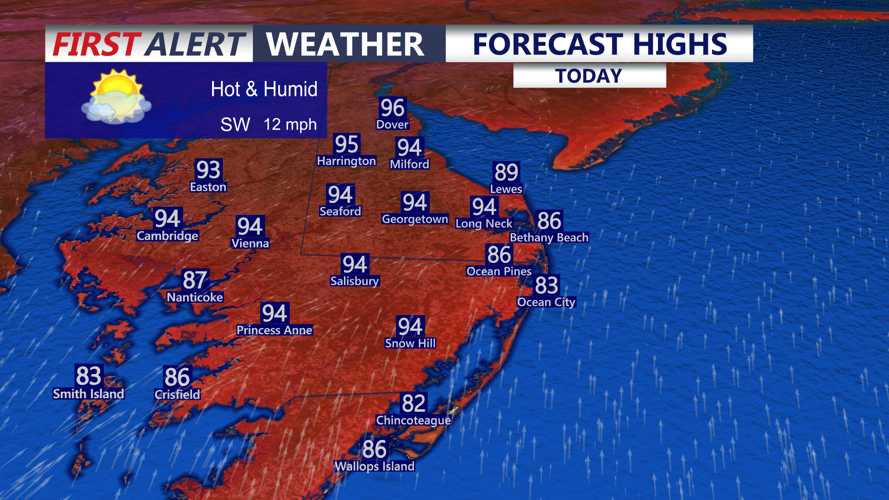
Highs today will climb into the low 90s inland, with mid-80s at the beaches. Southwest winds will run 10 to 20 mph, while the combination of heat and humidity will make it feel closer to 98 to 103 degrees at times.

Highs in the low 90s inland, mid to upper 80s at the coast, heat index: 98° to 103°.
Beachgoers should use caution along the Delaware, Maryland and Virginia beaches, where a moderate risk of rip currents is in place. Surf will run 1 to 3 feet, with ocean water temperatures in the low 70s.

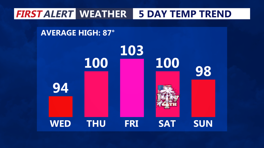
Triple digit record highs Thursday through the 4th of July, feeling even hotter with the heat index 105°+.
Tonight will stay very warm and muggy, with lows only falling into the upper 70s to low 80s. That limited overnight relief will become a major part of the heat risk over the next several days.
A strong ridge of high pressure building east from the Mississippi Valley, Great Lakes and Ohio Valley will lock in over the Mid-Atlantic today and hold through the holiday weekend. By Thursday, temperatures across Delmarva will soar into the upper 90s to low 100s, with heat index values reaching 105 to 111 degrees.

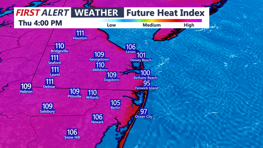
Heat indices soar 106 to 112 on Thursday.
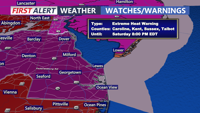
An Extreme Heat Warning takes effect Thursday afternoon and continues through Saturday night. Georgetown could make history, with a real chance of seeing three straight days at or above 100 degrees — something that has never happened there.
Records will be in jeopardy through the stretch. Georgetown’s record high for Thursday is 99, set in 1953. Friday’s record is 101, set in 1954, and Saturday’s record is 100, set in 1966.
Friday and Independence Day will bring sunny, hazy and humid conditions, with highs from 99 to 104. An isolated thunderstorm cannot be ruled out overnight Friday, but the bigger story will be the dangerous heat and lack of nighttime relief, as lows remain in the upper 70s to low 80s.
The weather pattern begins to shift by the weekend as the ridge breaks down and retreats south and west. That will allow a trough to slide into the Northeast, bringing a slightly better chance for showers and thunderstorms, especially Saturday and Sunday afternoon and evening.
A cold front is expected to finally snap the heat wave Monday, bringing scattered showers and storms. By Tuesday and Wednesday of next week, temperatures should fall back into the low to mid-80s, offering Delmarva a noticeable break from the extreme heat.
