


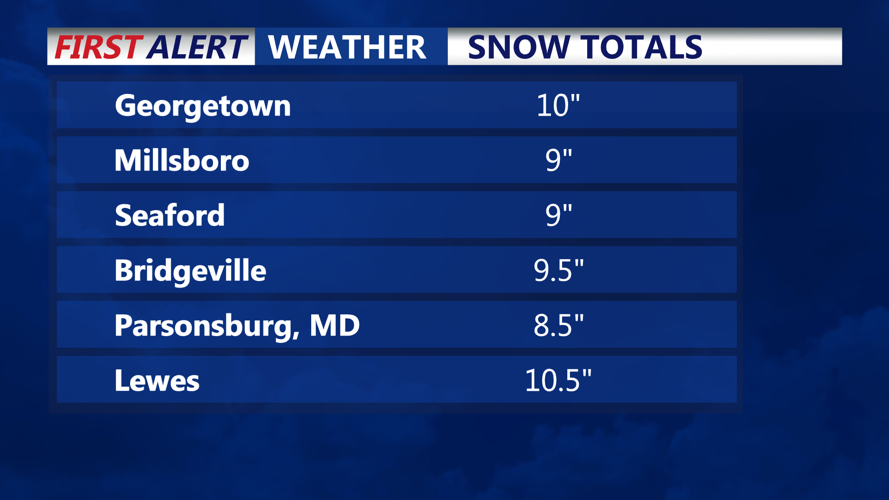


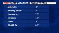

Delmarva - We has been hit hard by a winter storm, with reports of 6-10+ inches of snow accumulating across the region. As expected, snowfall amounts quickly taper to the north, with far southern New Jersey seeing similar totals. Mixed precipitation briefly reached Sussex County, Del., but much of the region will see patchy light snow or flurries throughout the afternoon before another round of snow moves in this evening.
Forecasters anticipate the evening snowfall to bring an additional 1-2 inches to the hardest-hit areas of Delmarva and far southern New Jersey. Radar analysis and observations suggest that any areas experiencing a mix of rain or sleet in southern Delaware and Maryland’s Eastern Shore will transition back to snow later today. North of Delmarva, additional snow totals this afternoon should remain under an inch.
Snowfall is expected to taper off completely by around 1 a.m., but residents should brace for strong winds and frigid temperatures overnight. As the storm’s low-pressure system moves offshore, gusty winds will develop, creating blowing snow conditions that may reduce visibility on roads. Overnight lows will plunge into the teens, making for a dangerously cold night.
Roads across the region remain snow-covered and slick, and drivers are urged to use caution, especially as blowing snow reduces visibility later tonight. Residents are advised to secure outdoor items and stay off the roads if possible.
