


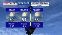


DELMARVA -- A beautiful Tuesday is underway across Delmarva, with mostly sunny skies and afternoon highs in the low to mid 50s for the peninsula.

Beautiful afternoon, mostly sunny skies, highs in the low to mid 50s. Turns breezy this evening.
Clouds will gradually increase tonight as a warm front moves through. Temperatures will dip into the mid to upper 30s, and winds will stay noticeable with gusts up to 25 mph.

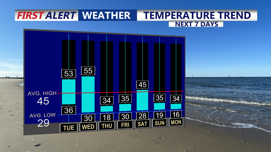
Two shots of arctic air on the way over the next 7 days.
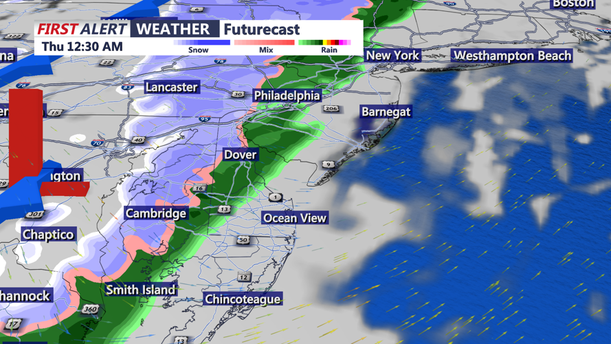
Wednesday remains seasonably mild — mostly cloudy with highs in the mid 50s — but attention shifts to a storm system expected to bring a period of precipitation Wednesday night through early Thursday morning. For Sussex County, that likely starts as light rain, with the potential for a brief mix or change to snow late Wednesday night into early Thursday as colder air deepens. At this point, the chance of significant accumulation appears low.

Cold front brings a round of showers early Thursday morning that could change to some brief snow showers. Not expecting an accumulation.
Behind the system, much colder air arrives quickly. By daybreak Thursday, temperatures are expected to fall into the mid 20s to near 30 degrees, and a gusty west-northwest wind could drive wind chills into the teens to low 20s. Thursday looks blustery and raw with winds 15 to 25 mph and gusts potentially 30 to 35 mph, with highs only in the upper 20s to mid 30s. Cold, biting wind chills continue into Friday, when lows could drop into the teens to low 20s and wind chills may fall to the single digits at times. Highs Friday stay in the low to mid 30s.

Wind chills falling to near the single digits into Friday morning.
Looking ahead, a couple of weaker systems could bring light wintry precipitation over the weekend, though confidence in timing and coverage remains low and overall amounts look limited. For now, chances appear low (around 20%), with the possibility that some spots only see a few sprinkles or flurries. After a brief return closer to normal temperatures Saturday, colder-than-normal air may slide back in Sunday into early next week.
