


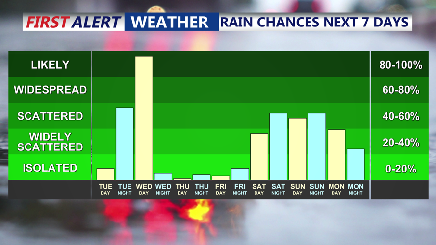


DELMARVA - Sussex County will enjoy another mild and mostly dry day Tuesday before wet weather and falling temperatures arrive overnight into early Wednesday.
The day begins with increasing clouds as a cold front slowly approaches from the northwest. High temperatures will once again climb into the upper 70s to low 80s, thanks to a continued flow of warm, moist air from the south. Winds will remain light but steady out of the south throughout the day, helping to maintain unseasonably warm conditions despite the cloud cover.
While most of Tuesday should remain rain-free across Sussex County, a few spotty showers are possible in far western areas by late afternoon. However, the bulk of the rain will hold off until after dark.
By Tuesday night, an upper-level disturbance and surface cold front will move closer to the region, triggering widespread showers and possibly a few embedded thunderstorms during the overnight hours. Rainfall could be moderate at times, with totals averaging between three-quarters of an inch and one inch. Some isolated areas could see slightly higher amounts.
No severe weather is expected, but thunder and occasional gusty winds cannot be ruled out overnight. Lows will stay relatively mild — in the low 60s — ahead of the front.
Rain will continue into early Wednesday morning before gradually tapering off from west to east. As the cold front pushes offshore by late Wednesday afternoon, high pressure will begin to build in from the west, bringing cooler and drier air. Highs on Wednesday will be noticeably cooler, reaching only the upper 60s to near 70.
By Wednesday night, temperatures are expected to fall into the 40s across Sussex County under clearing skies.