


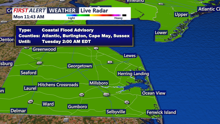
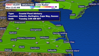

DELMARVA - Another round of minor coastal flooding is expected late Monday evening into early Tuesday along the Delaware beaches and Delaware Bay, with water levels running high near the new moon.
Low-lying areas near shorelines, tidal waterways and back bays could see minor flooding around the Monday evening high tide cycle. The advisory includes Delaware beach communities such as Lewes, Rehoboth Beach, Dewey Beach, Bethany Beach and Fenwick Island.
Drivers should watch for water on vulnerable coastal roads, especially near bayside neighborhoods, marina areas and tidal crossings. Minor coastal flooding can also affect parking lots, yards and other low-lying properties close to the water.
Outside of the tidal flooding threat, the forecast remains quiet through late Tuesday evening. Skies will be mostly clear late Monday night, with lows in the mid-60s along the beaches. Northwest winds are expected at 5 to 10 mph.
Tuesday is expected to be sunny and seasonable for the coast, with highs in the mid-70s. Winds will start from the north at 5 to 10 mph before turning southeast at 10 to 15 mph during the afternoon. Tuesday night will be partly cloudy, with lows again in the mid-60s and southeast winds around 5 to 10 mph.
Tides will remain somewhat elevated into midweek but should generally trend lower with each cycle after Monday night.
Looking ahead, Sussex County could see a more active weather pattern later in the week. Severe thunderstorms are possible Thursday afternoon and evening as hotter, breezier and more humid conditions develop ahead of a cold front. Damaging winds would be the primary concern if storms organize.
