


DELMARVA - It was another sweltering day Monday as highs reached the low 90s across the region. The combination of heat and humidity fueled drenching downpours that developed along the sea breeze, striking many of the same communities that were inundated by heavy rain just 24 hours earlier.
Neighborhoods stretching from Long Neck through Ocean View and the eastern parts of Sussex County along Coastal Highway saw rainfall totals between two and four inches in about an hour. These intense storms again raised concerns about localized flooding and difficult travel during the afternoon and evening hours.
On top of that, we had a brief tornado. National Weather Service in Mt. Holly confirms a brief weak tornado occurred just after 1PM Monday afternoon east of Frankford, DE. Reports of trees down in the area. There was an active severe thunderstorm warning during the time of this, but no tornado warning. A complete report will follow in the coming days.

The National Weather Service confirmed a brief tornado occurred Monday afternoon just east of Frankford, DE.
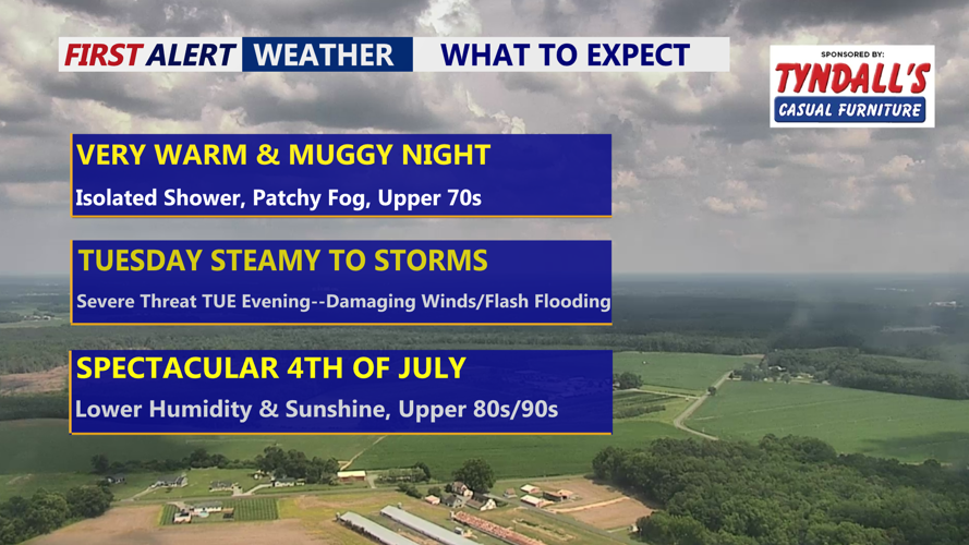
Heading into Monday night, conditions remained very warm and muggy. Partly cloudy skies were expected, along with the possibility of an isolated shower or thunderstorm lingering overnight. Lows in the upper 70s to low 80s, with patchy fog developing toward daybreak.
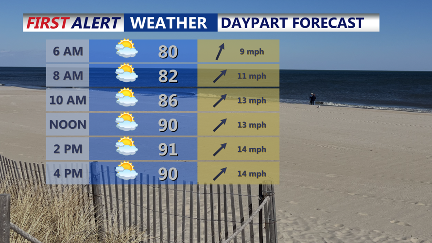
Tuesday will bring another hot and steamy day across Delmarva, with mostly sunny skies and temperatures ranging from the upper 80s to the low 90s.

Mostly sunny hot and humid highs in the low 90s, showers and storms move in during the evening.
While much of the day should remain dry, the approach of a cold front later in the afternoon and evening may trigger additional scattered showers or an isolated thunderstorm, especially closer to the coast.

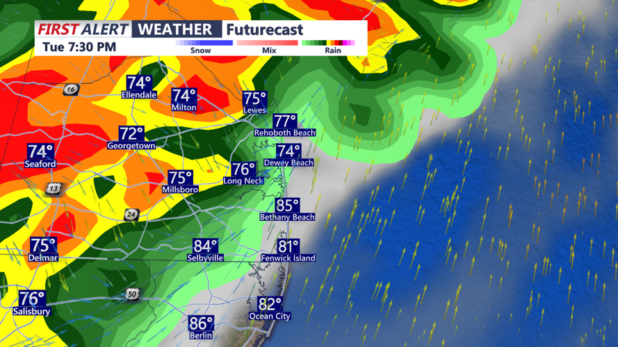
Storm Prediction Center has a "Slight" risk (2 of 5) across much of the Eastern Shore, western Sussex County and points north. Damaging winds and flash flooding are the primary threats.
The Storm Prediction Center has a "Slight" risk (2 of 5) from the Eastern Shore and points north of Salisbury and western Sussex County. Primary threats are damaging winds and flash flooding. There is a lot of moisture for storms to tap into plus the overall movement of these storms will be slow, increasing the risk of flash flooding. The Weather Prediction Center has a "Slight" risk of excessive rainfall over the peninsula.

A line of showers and t-storms will push into the peninsula after 6PM Tuesday through the evening.
The severe weather threat is expected to gradually diminish by late Tuesday night as the front slows its progress and settles near the coastal plain. Overnight lows will cool slightly, dipping into the mid-60s to low 70s as drier air starts to filter into the region.
By Wednesday morning, the cold front should be positioned just southeast of the area, allowing dew points to drop and delivering a modest break from the oppressive humidity. While temperatures may not fall significantly, the lower moisture content in the air will make for a more comfortable feel.
Shower and storm chances will fade quickly through Wednesday morning as high pressure begins building over the region. Dry conditions are expected to persist through Wednesday afternoon and Wednesday night, with pleasant overnight lows in the 60s.
Looking ahead, the forecast becomes more favorable for outdoor plans. The end of the week and the Fourth of July holiday should bring plenty of sunshine and seasonably warm temperatures. High pressure will remain in control Thursday through Saturday, keeping conditions largely dry. Daytime highs are forecast in the upper 80s to around 90, with dew points in the more tolerable low to mid-60s.
By Sunday, temperatures will climb closer to the lower 90 again, and humidity will start to increase as high pressure shifts offshore. While an isolated shower could return late in the weekend, most of Delmarva can expect a stretch of generally pleasant and settled weather as the holiday approaches.