


DELMARVA -- A beautiful summer day is unfolding across Delmarva, but a strengthening ridge of high pressure will set the stage for an extended stretch of dangerous heat later this week.
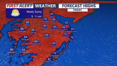
Mostly sunny skies are expected Tuesday with highs in the upper 80s to low 90s inland. Beach communities will stay cooler, with highs in the upper 70s to low 80s as southeast winds blow at 10 to 20 mph. Tuesday night will be mostly clear, mild and muggy, with lows in the upper 60s.

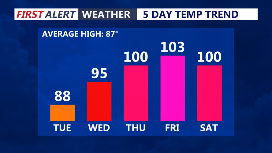
Temperatures rising into the upper 90s tomorrow, pushing into the low 100s through late week.
The heat begins to build quickly Wednesday. Highs are expected to climb into the upper 90s, with humidity making it feel closer to 97 to 101 degrees.
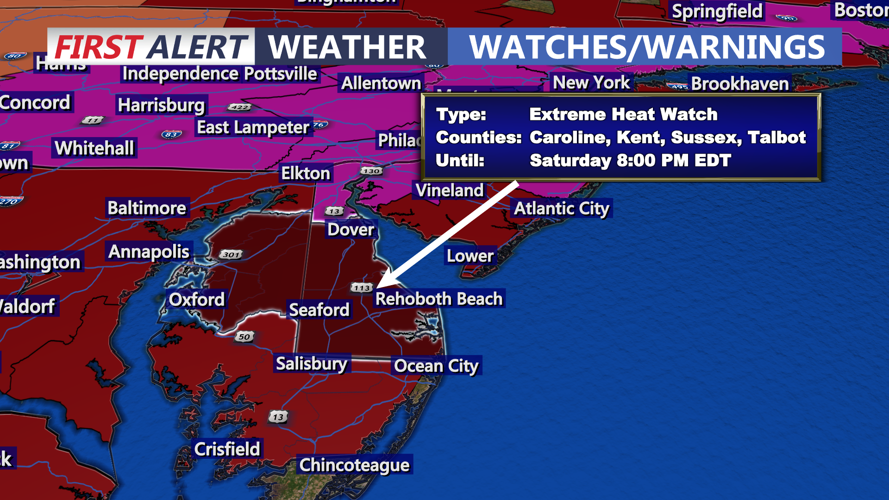
An Extreme Heat Watch is in effect for Sussex and Kent counties in Delaware, along with Dorchester, Wicomico, Worcester, Somerset, Talbot and Caroline counties in Maryland, from Thursday afternoon through Saturday evening. Heat indices could reach 105 to 110 degrees at times during the hottest part of the week.

Extreme Heat Watch in effect from Thursday through 8PM Saturday.
The hottest days are expected Thursday and Friday, when inland temperatures may surge from 100 to 105 degrees. All-time record high temperatures could be challenged in parts of the region as the ridge strengthens over the Mid-Atlantic.

Record highs are in jeopardy Thursday-4th of July, triple digit high temperatures.
The heat will ease slightly by Independence Day as the ridge begins to weaken, but highs may still reach the mid-90s to near 100 degrees. Heat indices could remain near or above 100, keeping heat-related impacts possible even as temperatures slowly come down.
Sunday and Monday should bring some improvement, though highs are still expected to remain in the low to mid-90s with humid conditions continuing.
The holiday weekend may also bring isolated afternoon and evening thunderstorms, especially from Friday through Sunday. Any storms that develop could become strong, and outdoor plans may be affected by both the heat and the threat of thunderstorms. Better chance of widespread storms comes Monday as a cold front pushes through the region.
Residents and visitors should limit strenuous outdoor activity during the hottest part of the day, drink plenty of water, check on vulnerable neighbors and never leave children or pets in vehicles.
