


DELMARVA - Quiet weather continues across Sussex County late Saturday evening as high pressure shifts offshore. Skies will be mostly clear early tonight, with increasing high clouds developing after midnight. Winds will remain light, turning slightly southerly, and overnight lows are expected to fall into the mid-20s to mid-30s.
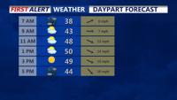
By Sunday morning, a dry cold front will cross the area from west to east. No precipitation is expected with the front, but winds will increase and shift from the southwest to the northwest by late morning.
Sunday afternoon and evening will turn noticeably breezier, with northwest wind gusts reaching 25 to 35 mph at times. Despite the colder air moving in, temperatures are expected to rise higher than Saturday, reaching the low to mid-40s, with a few spots possibly nearing 50 degrees due to stronger daytime mixing.
Skies will be partly sunny through the afternoon, then gradually clear by late Sunday evening as high pressure begins to build back in. Temperatures will trend downward after sunset, setting up a colder Sunday night.